

I’ve been up and down Medicine Bow Peak eight times since I was eight years old. Needless to say, it is my favorite place in the whole world.
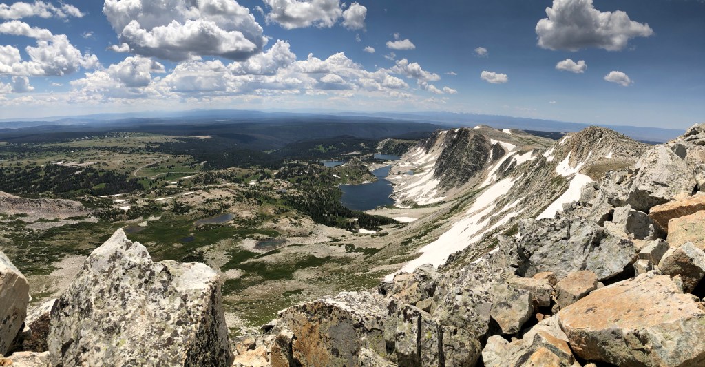
Medicine Bow Peak is the prominent peak of the Snowy Range mountains in southeastern Wyoming, and rises to an elevation of 12,018 feet (it was 12,013 for the longest time until a new height assessment). Located only thirty-five miles west of Laramie, this is a super accessible peak to climb, with three trailheads.

My elementary school climbed this mountain at the start of every school year… yes, all twenty of us (yay rural Wyoming!). However, it is important to not underestimate it. It is a lightening prone summit, and afternoon storms can build and roll in rapidly. Also, there is a lot of exposure, cornices of snow, and rocky trails. So like any hiking experience, you have to respect nature, even if it is a fairly “easy” mountain to climb. Aim for early morning climbs in the summer months to avoid storms (“below treeline by noon!” mantra), and for heavens sake, don’t wander out on snow on the cliffside – there probably isn’t land under some of that snow!
Wyoming Highway 130 is closed in the late fall/winter/spring months. The road is usually open by Memorial Day weekend, sometimes earlier, but easy access to Medicine Bow Peak will elude you for a little longer unless you have proper snow mountaineering equipment (ice axe, crampons, knowledge and skills) and/or are backcountry skiing. I’ve hiked the summit snow free as early as the end of June, and with significant snow fields even well into July. It merely depends on the snowpack every year. Mid-to-end-of-July and August are you best months, with fall months also an option (but remembering snow and ice comes fast to that elevation in the fall).

My trailhead of choice is the West Lake Marie Trailhead, leaving clockwise, and I use the Medicine Bow Peak Trail and Lakes Trail to make a roughly 7 mile long loop. I like finishing the hike with the gentle rolling grade along the glacial lakes at the base of the mountain. This trailhead can be busy in the summer months, but there is another parking lot just a smidge up the road at the Tipple Creek Trailhead. It is also possible to park at the Mirror Lake area.

For a shorter hike, it is possible to do a shorter 3.5 mile out and back from the Lewis Lake Trailhead. This is a shorter route, but I find it to be a lot steeper as you’re going both up and down the steepest part. Lewis Lake Trailhead also serves as a trailhead for other hikes in the area, including Gap Lakes and Lost Lake.


Fun Fact: A commercial airliner crashed into Medicine Bow Peak in the 1950’s. Read about it here You can still see wreckage!
There is camping in the area, though it can be very busy on weekend both in established campgrounds and dispersed areas.


Leave a comment