
September 17, 2018


With all the rain the night before, I was scared to open my eyes in the morning in Vík, as I didn’t want rain on our final day in the wilds of Iceland. Once I pried them open, I realized I didn’t hear rain, and that there was blue sky!
Today had a bit of melancholy hanging over it. After weeks on the road traveling through Iceland, this would be our last full day “out in the nature” before heading towards Reykjavík and then heading back home after that. This day would also have some of the most spectacular spots of our entire trip, ending our trip with a bang.
We headed early out of Vík on the Ring Road, and turned off shortly on Road 215 which would take us down to Reynisfjara, or the famous black sand beach. We would pass by Iceland’s southernmost farm, Garðar, on the way.


Early was good, and we arrived at Reynisfjara by 7:45am. Reynisfjara blew my mind. I had no idea I would fall in love with it as much as I did, and that it would become one of my favorite spots in Iceland. The beach really isn’t sand, but instead is composed of small lava pebbles, which jumped into my boots as I tried to walk on it, and also makes an interesting sound with the waves. Basalt columns made up the walls of Reynisfjall, the mountain that looms over the beach, which adds to the awesomeness of the whole place.
Oh the waves! This beach is actually quite dangerous, tourists die here every so often. There is no landmasses between Reynisfjara and Antarctica, so the waves can literally develop over hundreds, if not thousands, of miles. The current is quite strong, and every few minutes or so “sneaker waves” attack. Sneaker waves are waves that are simply much larger than those before and after them, and often come up way higher on shore than someone is expecting. Pretty much you just really have to respect Mother Nature when visiting Reynisfjara, and definitely do not think of jumping in the ocean here for a swim!


We spent about an hour at Reynisfjara, thought I think Kubo and I both can agree that we could’ve spent a lot more time if given the chance! But a busy day awaited, so we headed back up Road 215 to the Ring Road, and once again, quickly turned off on Road 218 to head towards Dyrhólaey.


There’s two options for viewing Dyrhólaey – the upper route, and lower route. The upper route gets a reputation for being a “scary Icelandic road,” so naturally this is the route we had to take, and once again we didn’t find it to be anymore unusual than we’ve come to expect from Iceland in terms of steepness and curves. We did some some terrified looking drivers on it, though!
Dyrhólaey was once an island that has become swallowed by the sandur to join mainland Iceland, and is a nature preserve that is closed several months every year for bird breeding season. During puffin season, this is a great place to see those buggers, but we had come too late in the year for that. So instead we enjoyed the magnificent views of Reynisfjara, Mýrdalsjökull and Eyjafjallajökull glaciers, the Atlantic Ocean, and the black sand coastline of southern Iceland stretching as far as the eye could see on this clear and sunny day.


Satisfied with the splendor of “almost Iceland’s southernmost point,” we headed back on Road 218 to rejoin the Ring Road, with Skógafoss our next destination awaiting us.


We parked, gathered our backpacks, and didn’t so much as really glance at Skógafoss as we headed towards the steep staircase that climbs to the top of the waterfall. I did manage to catch the stereotypical rainbow shot of the falls as we hurried on our way. We had big plans!

Fimmvörðuháls trail is a 25km hiking trail that goes from Skógafoss to Þórsmörk, and passes between Eyjafjallajökull and Mýrdalsjökull at the Fimmvörðuháls pass. The first 8km passes by some 26 waterfalls, and is nicknamed “Waterfall Way.” After about 8km, Fimmvörðuháls trail leaves the lush green and waterfalls behind with the beginning of the volcanic plateau and crossing of the Skógá river.
One day I hope to do the whole hike, but for this trip we decided the bridge over Skógá would be a good destination, and would still be one huge hike alongside my favorite volcano, Eyjafjallajökull.
Naturally, it’s an uphill hike, and it’s literally waterfall after waterfall! In other words, don’t bother with this hike if you don’t like waterfalls, ha! The sun was quite hot, so Kubo quickly ended up in shorts and I stripped off some layers as we continued on, stopping for a lot of photos and for me to talk nonsense to Eyjafjallajökull. We stopped for a burrito break along a stream crossing and then continued on, enjoying the sunshine and all the crazy scenery. The crowds thinned considerably after the first quarter mile past the top of the stairs, and just a mile or so in we were very much by ourselves except for the occasionally backpacker.


The sky had started darkening over the glacier, and things were quite cloudy once we arrived at the rocky start to the volcanic area of the hike. I knew I wouldn’t be happy unless we crossed the Skógá river, so I braved the bridge (it scared me so much, and I’m not sure why). We read the informational sign and Kubo pointed to a structure way off in the distance and joked that we should continue to see if it was the mountain hut. I was getting hungry again, so I’m sure I gave him “a look,” and returned across the bridge to begin our hike back (thought part of me really wanted to continue!).


As the sky continued to darken, we hastened our descent from the volcanic plateau, and I started munching on a burrito. We didn’t make it too far down the trail, maybe to the flat valley when Kubo stopped and suggested we put on our rain gear. I hesitated, as I was trying to eat my burrito, but without warning a massive storm unleashed on us. I quickly stuffed my DSLR in my backpack and got into my rain gear, soggy half-eaten burrito in one hand. It seemed apparent quickly that this was not the typical “rain for a few minutes” Iceland storm, and that we were in for some craziness.
The rain turned into snow as we climbed back out of the flat valley. The snow turned into hail which pelted us from every direction. My poor right hand was frozen from holding onto the burrito, which was becoming soggier by the minute. Finally I convinced Kubo to take some bites of it as I don’t like how wet tortillas feel. The trail turned into a raging stream, and huge puddless of water began forming. I’m a slow descender, and I got frustrated I couldn’t keep up with Kubo in the storm.
The hail turned into freezing rain, and then finally just into really hard rain. I began apologizing to the elves and Eyjafjallajökull for my horrible mispronunciations of the name, which obviously was the cause of all four seasons of fury to descend down upon us. I switched the burrito to my left hand to try to warm up my right hand. I got Kubo to take a few more bites, and finally gagged down the waterlogged final bites of the burrito, and sighed some relief that both of my hands could be in my pockets now.

For miles and miles we hurried along in the rain, not really stopping for photos or even doing much talking. With only a handful of miles to go, the skies let up and we were relieved of the torrents of water that were falling from the sky.

The last bit was just about survival for me, and I began whining as I was hungry and not use to walking this long. Kubo promised me ice cream if I would continue along, which made me happy, but I was exhausted as we reached the viewing platform at the top of Skógafoss. So exhausted I told Kubo I didn’t have the energy to go back to Carl to get my red raincoat for photos… that’s some exhaustion!

I only fell once descending the stairs from the top (go me!), and we hobbled over to grab some photos of Skógafoss. Since we were still in full rain gear, we passed through the crowds and got in front of the hoards so we were lucky to capture photos with no people in them! I walked up as close as I could get without getting in the river, and just stood there letting the spray from the falls hit my face.


Back to Carl we went, and we stripped out of our rain gear and emptied out our backpacks, which had taken on some water despite the rain covers. Kubo went down to the rive to dip his aching feet in while I called my parents who were handling some errands for me back home.
Overall we hiked 10.75 miles round trip in just a smidge over 6 hours total (that included talking our photos at Skógafoss).
(For what it’s worth, I never did get my ice cream…)
Onward we go!


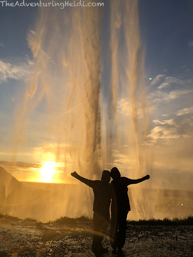
We arrived at Seljalandsfoss hungry and tired. Kubo and I spent a decent amount of time arguing about what to cook for dinner, so I eventually stormed out of the van, grabbing my rain gear, and heading towards the waterfall without him, still cross that I didn’t get my promised ice cream cone for being a big girl and finishing the hike that was my idea to do in the first place.
Tired, hungry, and missing my cat, I burst out in tears standing behind Seljalandsfoss, and just stood there crying for several minutes. The overwhelming emotions from 17 days of jam-packed travel and trying to comprehend everything that Iceland was just poured from me. Kubo appeared a few minutes later, and we said our apologizes for fighting about dinner and took to exploring the area. So yeah, I can mark crying underneath a waterfall in Iceland off my bucket list now!


Just a short walk down from Seljalandsfoss is another waterfall, Gljúfrabúi, that is hidden in a ravine. We splashed through the stream to get inside, and waited our turn for photos on the big rock.


I had picked out the campground at Hamragarðar right next to Seljalandsfoss for the night, which was the worse idea of the trip. It is PACKED and also was so muddy that a lot of areas were not possible for 2WD vehicles to even attempt to park (I’d even question 4WD vehicles attempting a lot of the spots). We were very close to eating our camping fee, and heading out towards Selfoss or Hella to camp, but finally Kubo squeezed Carl into a spot he was sure we could get out of in the morning, and we took to cooking up some much needed dinner. A faint aurora did come out to play, but we really didn’t get any photos. Kubo took to trying to get some night shots of Seljalandsfoss, which is lit up at night. I was so tired I didn’t even get out of Carl to look at the aurora, I just glanced through the windows. Zzzzzz…
Follow along on our entire 19 day Iceland road trip adventure! Click here for a comprehensive itinerary, with links to each day’s adventure.


Leave a comment