
Iceland Day 12 – September 12, 2018

If the evening of Day 6 was dedicated to going “into the wild” in the very much wild Westfjords, than Day 12 can be summarized as going “to the end of the world” as we’d travel from the Mývatn area to the tippy top of Iceland in the northeast. Along the same lines, if only something like 15% of tourists make their way to the Westfjords, I feel like NO ONE makes their way to the northeast.
Day 12 was suppose to look at lot different originally. I had planned to stick to Mývatn and Ásbyrgi. It wasn’t until I was explaining the itinerary to Kubo on a large road map of Iceland that I replanned this day, and it was all spurred Kubo pointing to Hraunhafnartangi and going, “why aren’t we going up there?” I hadn’t considered the far reaches of northeastern Iceland before this, but some quick Google searches later, and it was decided we had to travel up there, too! Because this Iceland road trip wouldn’t have been complete without the northernmost point of mainland Iceland… and the changes to Day 12 and Day 13 of our trip turned out amazing all thanks to Kubo’s curious mind!
We awoke early in the morning, despite our late night at the Nature Baths. There was a herd of sheep surrounding the Bjarg campground in Reykjahlíð, and they are quite rambunctious in the morning with all their loud “mehhhhhhhh-ing.”

I had a couple of things on the itinerary around Mývatn before we’d start heading north to the end of the world. After some breakfast and cleaning up, we headed up Námaskarð pass on the Ring Road, turning off on the road for Krafla (which I’m not sure actually has an actual road number, but is designated by a large sign reading “Krafla”).
This road led us to Kröflustöð, or the Krafla Geothermal Power Plant. In this highly volcanic area, 18 bore holes were drilled, and steam is led from the bore holes to turbines, transforming thermal energy into electricity. Truly making electricity in a clean way, as the byproduct is the steam! There is a visitors center on site, but it was too early to be open when we drove through. I found it very interesting to see how Iceland uses their natural resources to power/heat their country in a very environmentally friendly manner.


We made our way through the power plant and up a steep hill to the Viti crater just west of Krafla. Viti is an explosion crater that was formed during an eruption of Krafla in 1724, and there is a walking trail that goes around the top rim. The crater is filled with bluish-green water, but unlike the Viti crater found in Askja, people don’t swim in it.

The trail around Viti was incredibly muddy, which I had some warning about in my research prior to the trip. Not sure we were entirely prepared for the peanut butter thick, sticky mud, though! I wore my trail running shoes, and probably should’ve opted for my hiking boots. The trail around the top of the crater is about one mile in length, and gives really great panoramic views of the Krafla area and Leirhnjúkur lava fields. There is a bore hole (maybe?) nearby which is incredibly loud as steam pours ferociously out of the ground, but noise aside I found it really cool to get close to part of the power plant. About halfway around the crater the trail dips down through a highly geothermic area complete with boiling ground.


After circling the crater, and then a futile attempt at cleaning off the mud from our shoes, we set out back down the road. But first… shower time!
Wait, shower time?
Oh yes… shower time in the middle of a geothermal area alongside a road!

I was obsessed with finding this shower, and luckily Jeanie from Iceland with a View told me exactly where to find it (honestly, it’s not hard when you realize there’s only one road in and out of Krafla). As we pulled up, another camper van was leaving, giving us the shower all to ourselves. Did I shower? I’ll leave that up to you to decided. 😉 It was a great place to wash the Viti mud from our shoes, too! The water coming from the shower head is the absolute perfect temperature for bathing, and to think, there’s no hot water heater to run empty!
Hands down one of my favorite things in Iceland!

After wrapping up our shower shenanigans, we briefly stopped at Hverir geothermal area, which sits just east of Námafjall off the Ring Road. Marked by all sorts of geothermic features like boiling mud, steam vents, fumaroles, and a very strong sulphur smell, it is definitely a big contrast to the lakefront scenery of Mývatn just over the mountain pass. There are marked paths, which are important to stay on if one doesn’t not want to boil to death (or at the very least get severely burned), including one that climbs to the top of Námafjall.
Kubo and I grabbed some quick photos, but decided to forego any hiking and exploring at Hverir since I didn’t find it much different than geothermal areas I had visited back home in Wyoming, and I much more eager to explore things that were not so familiar to Wyoming, such as the Arctic Ocean (or any ocean in general, ha!).


Overall, I personally feel I could spend a few days in the Mývatn area, as there’s so much to see and do, with a variety of landscapes to boot. Sadly, we didn’t have the time to dedicate to spending more than overnight here during this trip, but luckily I think I’ll have no problem working Mývatn into a future trip!
We made our way back to Reykjahlíð, stopping quickly to refuel Carl before heading out of town. I had planned for us to take Road 87 north, but we were quickly stopped by a road closure sign that jarred my brain into remembering I wanted to check the status of closure, and had noted it on my To Do list pre-departure. Adding a little extra to our drive, we had to detour around Mývatn on the Ring Road and backtracked a bit of what we had driven the previous day until we came to Road 85, which we were able to take north and head us in the right direction.


The drive on Road 85 was pretty uneventful, and we just soaked in the views and blue skies (this would be our final day without rain in Iceland). Our next major stop was for the little known Æðarfossar just south of Húsavík. We turned down Laxamýrarvegur, a small road that dead-ended at a small picnic area and the waterfalls.


Æðarfossar, though not huge waterfalls, are still very impressive by the scenery that surrounds them. The falls are on the Laxá river as it flows out into Skjálfandi bay. We parked at the end of the road, and followed a trail that led down a staircase to the shore of the river, where there were more picnic areas, and a couple of bridges that led out to rocks in the river.


After getting our waterfall fix for the day, we continued on Road 85 towards Húsavík, sadly missing the geothermal pond that is filled with pet goldfish have turned loose (yes, this is a real thing!). I had it on the itinerary, but it slipped my mind and we drove right past!
We briefly stopped in Húsavík – I think to wash Carl, but honestly I’m having a hard time recalling why we stopped exactly, and then continued along the shores of the ocean on Road 85.

I think we debated this whole trip on if Iceland is bordered by the Arctic Ocean in the north or not. Some online sources say yes, that is the Arctic Ocean, and others say Iceland is firmly in the north Atlantic Ocean. Obviously, boundaries of oceans are fluid (ha, I made a funny!), so I suppose how would we know where the Atlantic stops and Arctic begins? Until I’m corrected, I’m going to call the ocean we saw from northern Iceland as the Arctic Ocean… and maybe one day I’ll find the one, real correct answer to the ocean debate!


We made our way slightly inland on Road 85 for our next major stop, Ásbyrgi.
At the northern end of Jökulsárgljúfur canyon is a horseshoe shape canyon called Ásbyrgi. According to folklore, the god Óðinn was riding his 8-legged horse, Sleipnir, in this area and Ásbyrgi was formed from one of the hoof prints. Naturally, there’s plenty of geological explanations for the canyon, but I’m sticking to the 8-legged horse hoofprint theory! To boot, Ásbyrgi is consider to be the capital city of the elves. Oh man, now I have to be on my best behavior to appease all the elves watching me!
Ásbyrgi is part of Vatnajökull National Park, and we made a quick stop at the visitors center at the entrance before continuing into the canyon.

I’m sure like all of Iceland, Ásbyrgi is stunning all year around. But it is downright breathtaking in the autumn! The reds, oranges, and yellows contrasted perfectly with the dark canyon walls, and definitely did not feel like you were in Iceland, but instead maybe in a forest in Vermont or somewhere!
We drove down to the end and found a parking spot and took to making some soup for lunch. Unfortunately by now I was not feeling too well, and sadly most of my experience with Ásbyrgi was fretting about how far I’d get from the bathrooms – thanks undercooked hamburger from the night before (insert very angry expression here!).
There are numerous hiking trails all over Ásbyrgi, some very short and some to fill an entire day. Originally before Kubo had pointed out the far reaches of the northeast and suggested we should go there, I had planned to camp in Ásbyrgi overnight and do some extended hiking. But since this was now a quicker stop, we set off to Botnstjörn pond, which is fairly close to the inner parking lots. Hiking through Ásbyrgi is absolutely amazing with the autumn colors, and steep canyon walls, and is more proof to the insane variety of Icelandic terrain!


After viewing Botnstjörn pond from the lower platform, we continued upward to an upper viewing spot, and then a narrow trail that went along the canyon walls. The views looking over the canyon are almost overwhelming with the bright fall colors and steepness of the walls.


We started down from our cliffside view point and was walking through the woods when I started getting horrible stomach cramps that had me doubled over on the trail. I was frustrated I was feeling so sick in an area I really wanted to explore, but finally I threw my camera at Kubo and took off sprinting towards the parking lot and bathrooms. (Seriously, hamburger needs to get cooked well done, Iceland! Sure Heidi, why did you eat it? Well, you tend to eat your $35 hamburger regardless of how it’s cooked, but I learned my lesson… for a few days!)
Well, it wasn’t my dream trip to Ásbyrgi thanks to feeling ill, but I’m happy we were able to spend some time in the canyon and take a short, but gorgeous hike!

Whereas most travelers head south towards Dettifoss/Selfoss, or west to Húsavík, after Ásbyrgi, we continued north on Road 85, leaving behind civilization apparently. Into the wild we were going!


The landscape changed again as we entered the Melrakkaslétta peninsula. This peninsula is relatively flat, and has an overwhelming sense of abandonment and loneliness to it. However, it is home to thousands of migratory birds, so it has that going for it! Every website I could find about Melrakkaslétta talked about how even Icelanders “don’t bother coming here.” Considering we hadn’t really passed any other cars since leaving Ásbyrgi, there is probably truth to that. But as someone who actually likes being in the middle of nowhere, I was drawn to the landscape and mood.


We had plenty of moments of feeling like we were in the middle of nowhere in Iceland, but there is nothing like driving across the Melrakkaslétta peninsula to make you feel like you’re the last humans left on earth. And we had a couple of crazy encounters that almost had me convinced that indeed Kubo and I were the last ones left.
I had watched the indie film Bokeh a few times before heading to Iceland. Though kind of a terrible movie, I liked it for it’s Iceland scenery and getting me amped for our trip. The plot focuses around an American couple that somehow survive an apocalyptic event while vacationing in Iceland, and end up being the last two people alive (presumably). Literally everyone else had up and vanished. Poof!
While heading on Road 874 towards Raufarhöfn, we came across a car parked in the middle of the oncoming lane, headlights on and seemingly like the engine was running. AND NOBODY NEAR IT. Kubo and I both went, “hmmm, that’s kind of weird.”
Miles on down the road, still without seeing any other form of human life, we come upon another car in the oncoming lane. Parked. Headlights on, appearing to still be running. AND NOBODY IN SIGHT. Upon seeing these I legit freaked out, immediately thinking of Bokeh, and trying to rack my mind on if we had seen any bright flashes of light or anything strange in the last hour or so since we had seen any other humans. I mean, why were these two cars parked in the middle of the road, still running, without anybody in sight? The landscape of Melrakkaslétta is quite flat, so it would’ve been easy to see people out wandering around near their vehicles.
Oh my god.
I remained scared and nervous until Raufarhöfn came into sight, and thankfully, other human beings. Not that Raufarhöfn is a bustling metropolis by any means, with less than 200 residents, but the sight of at least one other person was comforting. Until I began thinking that maybe we were going to be trapped in this isolated, northernmost town of Iceland for all of eternity. I think Kubo got a good laugh out of all my worrying.


We made our way through Raufarhöfn, and just as we were leaving the edge of town we passed an adolescent girl walking in the middle of the road who gave us hands-down the most evil glare I have ever witness in my life. I think Kubo giggled when he saw my face, because he knew I was just adding to the story in my head about all the crazy events of the last half hour or so.
Killer teen behind us, we continued north on Road 870, which is gravel, heading towards the end of the world.

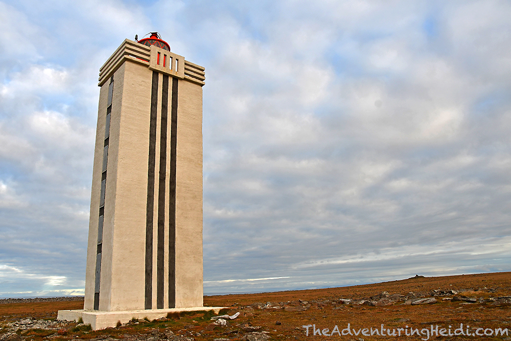
Our last destination was Hraunhafnartangi, which until 2016 was the northernmost point in mainland Iceland. Sadly in 2016 during a land survey, nearby Rifstangi took the honor, reaching 68 meters more north. 68 meters be damned, this is the closest you can get to the Arctic Circle in Iceland without traveling to Grimsey Island, where the Arctic Circle runs through the island. Hraunhafnartangi will get you within 3km, or about 1.86 miles, of the Arctic Circle. Sounds close enough to me!
We parked Carl off Road 870 as the track out to Hraunhafnartangi is very rocky and beyond the capabilities and clearance for most cars (though there was a Honda parked halfway down it… anything is possible!), and began our walk towards the end of the world and Hraunhafnartangi lighthouse. The shore is littered with fishing nets and other debris that has washed up (I had been warned by our American friend during the laundry debacle in Drangsnes, Westfjords, that this would be a discarded fish net capital of the world… she was right!), and at times the walking can be hard due to walking on large, uneven rocks. It is so beautiful and serene, and aside from the person belonging to the Honda who we only saw for mere seconds, we were all by ourselves.


We spend a long time soaking in the crashing waves, and marveling in the feeling that we had truly reached the end of the world. Then we turned our attention to the lighthouse, which was moved to Hraunhafnartangi in 1945 from Rifstangi.


Overall, we spent about one and a half hours at Hraunhafnartangi, and I think both Kubo and I agree that it was one of the highlights of our entire trip. We did miss out on getting our certificates documenting that we had indeed been to the (almost) northernmost point of Iceland at Hotel Norðurljós… maybe next time?
We headed back down Road 870 to Raufarhöfn, where we’d be staying the night. We made a quick stop at Heimskautsgerðið, or the Arctic Henge, but didn’t stay long, promising to return in the morning for more photos and a closer look. I was getting a bit grumpy and wanting dinner, and still was feeling slightly under the weather, so was eager to get into camp and relax.

Since we were all alone in the campground in Raufarhöfn, we had our choice of parking spots, and later on in the evening a lady came down from the nearby sports center to collect our camping fee. We were hoping to maybe catch the aurora, but sadly it remained overcast and cloudy through the evening and night hours. Here’s to hoping that we didn’t wake up as the last two humans left on earth!
Follow along on our entire 19 day Iceland road trip adventure! Click here for a comprehensive itinerary, with links to each day’s adventure.


Leave a comment