
September 11, 2018

Well friends, day 11 reminded us that indeed our rain-free luck of the start of our clockwise journey around Iceland had indeed run dry (ha!) as rain and clouds greeted us in Hofsós when we peered out the windows of Carl. Foregoing breakfast, we headed to the Hofsós town swimming pool, which sits on the edge of Skagafjörður, giving it the appearance of an infinity pool.
I think most Americans don’t get highly excited about the idea of a municipal swimming pool, but the ones in Iceland are nothing like what I’ve used back home in the U.S. Most are geothermically heated, and feature hot tubs and heated lap pools. Some even have waterslides and ice baths you can jump in. Iceland’s town pools are also pretty cheap, with the Hofsós pool charging 900 ISK (under $9 USD) to swim and shower to your heart’s content. Since the campground in Hofsós charges for showers, this was a more economic way to get in a soak/swim and a shower in the morning, too.
By now I had shed any American puritanical conditioning against being naked in public, and showered like a pro without my bikini on before entering the pool, and jumped into a hot tub to soak my body and attempt to wake up. Kubo eventually joined me, and we soaked for awhile, and then jumped into the lap pool, which was cooler in temperature, but still comfortable. This was the first time we noticed any chlorine in a pool in Iceland, which was strange after all our days of natural hot pots.

After getting our fill of warm water, we showered and prepared to continue on our journey… but not until we decided to buy ice cream bars from the pool and eat them for breakfast! The pool appears to be the local gathering spot for some of the town’s local ladies, and they got a chuckle out of us choosing ice cream for breakfast. After grabbing some coffee, we treaded out into the rain and back to Carl, where I promptly ruined my coffee by pouring cold milk into the boiling hot coffee, which instantly curdled the milk. Yuck. Grr. No coffee for me…

This morning’s route would have us following Road 76 around the coast of Tröllaskagi, until it turns into Road 82 in Dalvík, and takes us into Akureyri. I had originally planned for us to turn off on Road 82 before Siglufjörður, but the low cloud cover meant we would miss most of the mountainous scenery, so coastal route it was. (And now since I’ve become such a big fan of Trapped, I’m glad we got to see Siglufjörður!) We got to go through one tunnel, Strákagöng, shortly before Siglufjörður. We were feeling like tunnel pros by now, but still got awfully excited to see it!


After snapping some photos in Siglufjörður of the church and harbor, we continued on Road 76. If I only had seen Trapped before my trip, ha! I’m a sucker for finding spots in TV shoes and movies… but alas, I discovered Trapped about four months after coming home from Iceland 😦
Héðinsfjarðargöng was our next adventure, a set of two tunnels that links the towns of Siglufjörður and Ólafsfjörður. The two tunnels are 11km combined, making them the longest tunnels in Iceland. And to boot, they remain two lane for their duration! The tunnels opened in 2010, finally linking Siglufjörður and Ólafsfjörður in a more efficient manner.


Héðinsfjarðargöng spat us out in Ólafsfjörður, where we stopped for some brief photos, and then continuing on down Road 76, which included another short tunnel, Múlagöng.

We continued down Road 76, getting both kind of hangry and tired. I began googling for some bakeries we could grab lunch at in Akureyri since neither Kubo or I felt up to rummaging around and eating all the food we had in the van. I think the weather had us down, plus just the exhaustion of now eleven days of driving and soaking in all that Iceland had to offer. We cruised steadily down Road 82 along Eyjafjörður, eager to get to Akureyri.


Soon enough, traffic picked up and we came upon the outskirts of Akureyri, Iceland’s fourth largest city of over 18,000 people (hey, sounds like a big city for Wyoming, too!). We decided on Bakaríið við Brúna for lunch, which turned out to be an amazing choice!
I gotta admit, it was initially very confusing and hectic in Bakaríið við Brúna. It is very popular among locals, and they knew how to just shove (literally) past us confused travelers, and make their orders while Kubo and I scratched our heads wondering where the menu was and how it all worked. After the rush of locals subsided, we made our way to the counter, relieved that the gal working spoke English and was very helpful. She showed us the flatbread pizza menu, and Kubo and I each selected one, and then we ordered a bowl of all-you-can-eat goulash to split, and much needed coffees. The grand total was a little over $30 USD, which is crazy affordable for Iceland!

The food was hands down absolutely AMAZING and perked up our spirits and energy quickly. We definitely took advantage of the free refills of the goulash. Icelandic bakeries are definitely a hidden gem for affordable and great tasting meals!
Bodies and minds replenished, we carried on. I had planned for a grocery run in Akureyri, but we decided we were good on food for several more days, so we carried on, deciding to park near the harbor and take a quick walk around.


Leaving town we made a quick stop at N1 for a bathroom break, and Kubo bought some Icelandic Coke’s for us to try out. He also ended up meeting some car enthusiasts who worked at N1 and learned all about the racing scene in Iceland, and learned there was a track near Akureyri.
The Ring Road has actually been modified since our trip in September, as the Vaðlaheiðargöng tunnel opened in December 2018, eliminating Víkurskarð pass and shortening the Ring Road by 21km. Personally, I’m all for driving the mountain passes, so I am happy we got to experience the “old version” of the Ring Road as it left Akureyri!


Next up on the itinerary was Goðafoss, which is right off the Ring Road. Upon parking, we got to witness a rather comical case of road rage between two sets of tourists in the parking lot for the waterfall. I guess that Car B passed Car A too fast through a construction zone, and kicked up a rock that took a decent chip out of Car A’s windshield. Car A’s driver, therefore, proceeded to confront Car B’s driver, screaming “IMBECILE!” every third word, threatening to report Car B to their rental company for speeding and damaging other cars. This carried on for about 5-10 minutes in the parking lot in front of a crowd of onlookers, and ended when Car B’s driver jumped back into the car, and floored it on the gravel in the parking lot, spinning tires, making noise, and speeding off down the road without ever going to look at the waterfall. Car A’s driver continued yelling “IMBECILE” loudly and finally went to look at the waterfall. Kubo, being the curious creature he was, went to look at Car A’s windshield, and it indeed did have a very large chip. Eek. Hope they had gravel insurance!
Our afternoon entertainment done for, we donned the rain gear (for both actual rain, and waterfall mist) and headed out. Goðafoss means “Waterfall of the Gods,” and naturally has a story behind it. In the year 1000, Þorgeir Ljósvetningagoði made Christianity the official religion of Iceland. According to legend, it is said that upon returning from the Alþingi (parliament gathering), Þorgeir threw his statues of the Norse gods into the waterfall. Ta-da, you have Goðafoss!
Goðafoss is a beautiful waterfall, and there are numerous hiking trails to get to view points on both sides of the Skjálfandafljót river, which originates in the highlands at Vatnajökull. We followed the crowds to the viewpoint closest to the parking lot, scowling at those ignoring closed areas (and so it began again… the scowling at idiots who feel the need to walk where ever they please). After a few photos, we turned and walked away from the crowds, crossed the bridge that is over the river, and made our way down to the shore from the other side, which was a bit less crowded. While we were down on the shore we noticed kayakers queuing up to ride off the falls, so we watched for quite awhile so I could capture some photos. So cool!


We spent way more time at Goðafoss than I was expecting, but that wasn’t necessarily a bad thing. I definitely do not think Goðafoss is a “get out, snap a photo” type of place, as it is nice to walk along the river, see the other waterfall, and get different view points of Goðafoss itself. Not to mention seeing the kayakers were a special treat! And hey, now Kubo and I had newfound joy in the word “imbecile,” which we would just start yelling for any reason the rest of the trip.
After a short bit back on the Ring Road, we turned off on Road 848 to travel along the southern shore of Mývatn, our final general destination for today. Mývatn is the name of Iceland’s fourth largest lake, which formed 2300 years ago by a basaltic lava eruption, but also has come to describe the general area which is filled with the Krafla volcano, geothermal activity, pseudo craters, lava fields, and midges (pesky little gnat bug things that are apparently horrible in the summer, and still there in the autumn… Mývatn after all, means “midge lake”).
We followed Road 848 around Mývatn, briefly stopping for some photos of the pseudo craters at Skútustaðagígar and Höfði. Pseuodcraters are named as such because they appear to be volcanic craters, but are “rootless cones,” meaning there was no magma chamber and lava did not flow from them. They are formed from steam eruptions, and are common around the Mývatn area. There are several hiking trails around them, but we didn’t take the time to explore them.


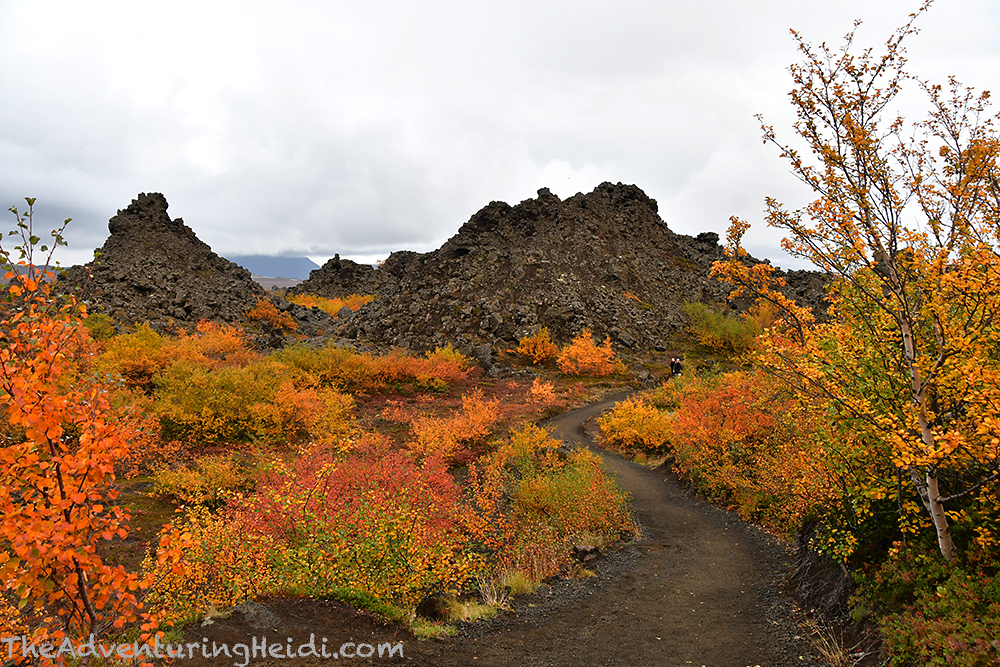
Our first major stop near Mývatn was Dimmuborgir, or “Black Fortress.” This area of extraordinary lava formations formed 2300 years ago by the eruption of the fissures Þrengslaborgir and Lúdentsborgir. As lava flowed over a lake, the water in the lake and sod begin to boil, and the vapor flowed up through the lava, creating pillars and other formations. There is a visitors center, cafe, and numerous hiking trails that branch out from the area.
Kubo and I selected the Kirkjuhringurinn hiking trail, denoted by red markers. I found the trails to be well marked, and we never felt lost even though it seemed like it could become a possibility when we first saw the area. The Kirkjuhringurinn is about 2.4km long, and is a loop starting and ending at the main trailhead, and leads to the feature Kirkjan.
Now, Dimmuborgir I’m sure is gorgeous all year around, but the bright oranges, reds, and yellows were spectacular as they contrasted the black lava. Hands down the best time to visit in my opinion (and from only seeing it in photos the other times of the year)!


As we wandered along Kirkjuhringurinn, we came to a trail junction that led to Jólasveinahellirinn, or Cave of the Yule Lads. We decided to head that way since we were doing okay on time, and loved the fact there were wild bilberries to pick along the trail (plus Kubo cannot resist a good cave).
Icelandic folklore time!
The Yule Lads are the thirteen sons of half-troll, half-ogre Grýla and her husband Leppalúði. Grýla has a huge appetite for children, and also has a child-eating cat, Jólakötturinn, who munches on children who do not get new clothes for Christmas. This big, happy family lives in Dimmuborgir. For the thirteen nights leading up to Christmas, the Yule Lads terrorize the citizens of Iceland – Stekkjarstaur (Sheep Cote Clod – he harasses the sheep), Giljagaur (Gully Gawk – steals milk from milk sheds), Stúfur (Stubby – steals pans to eat the crusts out of them), Þvörusleikir (Spoon Licker – steals spoons to lick them), Pottaskefill (Pot Scrapper – steals pots and eats what’s left in them), Askasleikir (Bowl Licker – steals bowls and licks them), Hurðaskellir (Door Slammer – wakes people up by slamming doors), Skyrgámur (Skyr Gobbler – loves skyr), Bjúgnakrækir (Sausage Swiper – steals sausages as they’re being smoked), Gluggagægir (Window Peeper – looks through windows for things to steal), Gáttaþefur (Doorway Sniffer – uses his large nose to sniff out bread), Ketkrókur (Meat Hook – steals meat with a hook), and Kertasníkir (Candle Stealer – follows children to steal their candles).


You can walk down into the Cave of the Yule Lads, and see their various possessions. Luckily none of them were home when we visited, though I feel like something was there causing mischief, as Kubo whacked his head hard on the ceiling of the cave, getting a small cut and bump.
We walked about 2.4 miles in Dimmuborgir, and spent about 1 hour 30 minutes exploring. I wish we had had more time to explore more of the hiking trails – I definitely could justify adding a whole day or more to the itinerary to spend in the Mývatn area, but alas we did not have the time on this trip (as I like to say… next time!).
Next up was the Hverfjall crater, a 1,300 foot tall tuff ring volcano that erupted about 2500 years ago. The road out to the parking lot of one of the two trails up to the rim was crazy bumpy, but nothing you can’t handle in any vehicle going slowly. We left the bright autumn colors of Dimmuborgir behind, and entered scenery that looked straight out of a space movie.

It’s only natural that the trail up Hverfjall was STEEP and loose, but I thought it was well-worth the climb. It was super angering to see people descending off trail, though, creating their own path on the fragile volcanic ecosystem. Come on, whyyyyyyyy?!?!?! It made the descent no easier than staying on the trail. Seriously, humans suck!

On top there is a trail that goes all the way around the crater, but we opted out of doing it.


After Hverfjall, we carefully drove the bumpy road out and headed to the Vogafjós Cowshed Cafe for dinner. There was a bit of a wait, so we put our name on the list and then went and visited the cows in the cowshed and took photos of the sunset over Mývatn. I had heard good reviews of their restaurant, and it is kind of unique in the fact there are large windows between the cowshed and restaurant so you can look a cow in the eye as you eat a hamburger. However, this would probably be our most disappointing restaurant encounter in Iceland. Frankly, I think it is way overhyped, and the service leaves a lot to be desired. Kubo enjoyed his lamb fillets immensely, but my hamburger came out pretty much raw (the microbiologist in me only eats well done hamburger). We waited forever for our food, and even saw several tables that were seated after we were receive their identical food orders in a much more quick manner. Definitely an experience for the lesson book, and sadly it cut into our time that we could spend at the nature baths. I will hand it to the manager, who allowed me to select a dessert for free since our meal took so long to arrive, and who could probably tell I didn’t appreciate when the server was rude to me when I asked why our meals were taking so long.


Jarðböðin á Mývatni, or Mývatn Nature Baths, was our final destination of the evening. Since we opted out of going to the Blue Lagoon on this trip due to its crazy high entry fees and crowds, this was the next best thing at half the price but the same milky blue, mineral-filled, geothermal power plant water runoff! Sadly we would only have about an hour here to soak due to our dinner taking forever, but we made the most of it. Since it was dark, I have no photos, and we really couldn’t notice we were floating around in milky silica water. The Nature Baths are quite large, and the temperature of the water varies depending on where you go. We first found the waterfall features, which served as a great back massager, before finding our own quiet corner to relax in. We tried to squeeze all we could out of our entry fee (roughly $92 USD for two of us), and stayed until the lights came on and the lifeguard got very insistent on kicking everyone out.
Because there are several campgrounds around Mývatn, I didn’t have a particular one in mind, so we chose Bjarg Camping, which is located in the town of Reykjahlíð. We rolled in just as reception was closing, about 11pm. This campground is gorgeous, on the shores of Mývatn, and very clean (and with lots of rules posted everywhere), but sadly we didn’t get to see much of it since it was dark, and we would leave early the next day.
Follow along on our entire 19 day Iceland road trip adventure! Click here for a comprehensive itinerary, with links to each day’s adventure.


Leave a comment