
Iceland Day 13 – September 13, 2018

The weather luck ran out.
My good favors I put into the elves must’ve expired, and we awoke to rain that would stay constant nearly all day during our 260km of driving. Raufarhöfn was just as quiet and empty in the morning as it was the evening before, and we never did shake the feeling that we were at the end of the world.

After a quick breakfast and willing ourselves out of the sleeping bag and into the damp Icelandic autumn weather, we headed up to the Arctic Henge, kicking ourselves for skipping it last evening when the weather was significantly warmer and drier.
Heimskautsgerðið, or Arctic Henge, is the brainchild of Erlingur Thoroddsen, and is still under construction. Its purpose is similar to Stonehenge – to capture light and shadows as a big sundial, and aligning just right on the solstices. I’ve seen stunning aurora photos taken here, but on a gray rainy day the photos came out a little less exciting. After ten minutes of photos and exploring, we headed back to Carl and turned south to take our round about way back to the Ring Road hundreds of kilometers to the south.


The dense clouds and rain shrouded most of the scenery, so photos were few (or blurry from the low light) and stops nonexistent until we reached Vopnafjörður, some 135km from Raufarhöfn. Carl’s windshield wipers had become streakier over the duration of our trip, so Kubo ran into the gas station to see if they had any of the correct size, and came out empty handed. Since I was taking most of the photos from this trip through the windshield, I grumbled slightly, but understood we were in the middle of nowhere essentially. The feeling of isolation didn’t dissipate after leaving Raufarhöfn we discovered.


We could’ve stayed on Road 85 after leaving Vopnafjörður to join the Ring Road, but that just isn’t the Heidi and Kubo style, so naturally we chose the highest mountain pass in Iceland that isn’t an F-road to drive instead – Road 917. I’ll admit to some feelings of second thoughts as I eyed the steady rain and thick clouds, but Kubo had no qualms about tackling another Icelandic mountain pass, weather be damned!
Our first itinerary item of the day came shortly after traveling on Road 917, Gljúfursárfoss. This waterfall on Gljúfursá tumbles dramatically into Vopnafjörður, and there is a hiking trail that wanders along Drangsnes (no, not the one in the Westfjords where the washer held our clothes hostage… I swear every place name in Iceland is used several times!). It was raining HARD when we arrived, so for the first time since arriving in Iceland I applied the Rain Sleeve to my DSLR, and after Kubo and I dressed in our own rain gear, we stepped out into the storm.


Sadly the weather wasn’t conducive to anything more than some quick photos before rushing back to the van. It looks like a beautiful area to hike in with better conditions!

Down Road 917 we continued, until we came to the base of Hellisheiði pass, which I termed “Hell is Heidi,” since Icelandic pronunciation was still beyond my capabilities after two weeks. Not sure that’s a flattering translation seeing as I am a Heidi, but whatever! Kubo stopped to stick the Go Pro on the outside of the windshield (kind of a dumb moment considering it was raining and the lens got water spots quickly), and onward we went into the thick clouds.


Like the photo caption said, I’m sure the drive over Hellisheiði is beautiful… when you can see something. All we saw was yellow road markers, the black gravel in front of us, and a wall of white. However, luckily the clouds lessened as we crested the summit and began our descent, giving us a teaser of the winding switchbacks as we would descend towards Héraðssandur on the southern end of Road 917. Squeals of excitement came from both Kubo and I as we parked and jumped out to grab photos… more Icelandic road porn!!


Can’t believe I had second thoughts about driving Road 917… how silly of me!!!


Before long, the Ring Road came into view, and the big bridge over Jökulsá á Dal. There is a parking lot and restrooms here, so we took the chance to get out and stretch our legs, especially since the rain let up long enough that we didn’t have to get dressed in the rain gear.


Our next stop was Egilsstaðir, the eastern region’s largest town. We definitely needed to restock our groceries after a little more than four days since shopping. I suppose you could say we were having some Bónus withdrawals! The cashier in Bónus was one of the chattiest Icelanders we encountered on our trip, and definitely wasn’t afraid of small talk as she filled us in on how Costco said they would put the grocery store chains out of business when they came to Iceland, but yet that didn’t happen and she didn’t understand why anyone would need to buy that much food at one time. Which I totally agree with her, and always wonder why American tourists are always so eager to rush off to Costco when visiting Iceland (I’ve never seen the inside of a Costco, so maybe I’m missing something?) – not to mention that Bónus is really cool. Either way, it was a random and pleasant chat, considering small talk isn’t really a thing in Europe like it is in the United States. By now slight twinges of homesickness were hitting me between missing my cat and still being annoyed by the food poisoning from undercooked hamburger, so having that small talk that is my cultural norm perked me up a bit.
After putting our groceries away in the “pantry” of Carl (under seat storage in the back), we topped off his fuel tank, and then headed out of town on Road 93. I really liked the feel of Egilsstaðir, right down to their American style semi trucks (you know, the ones with noses and not flat faces!) and huge wicker basket flower planters that reminded me of my mom’s love for wicker baskets.
The drive on Road 93 was a culmination of nearly five years of anticipation since seeing The Secret Life of Walter Mitty, but I’d have to squash my excitement for a moment for our next stop, the hike to Fardagafoss.
Fardagafoss sits on Miðhúsaá, and use to have a large cave behind it that was occupied by a female troll, but sadly most of the cave has collapsed. Naturally, the trail is uphill to the waterfall, but is a gorgeous hike with views of the river, other waterfalls, and Lagarfljót lake behind you. Added bonus was bilberries alongside the trail, though it was clear after the first few that they were past their prime ripeness and had gotten quite bitter.


Near the top is a tube that had a register in it, which I pulled out and signed, and flipped through to read a few entries. Kubo would make his own entry with the statement, “Eat more horse.” Ha!
There is a steep rocky trail that leads down to the base of the waterfall, and has a chain to hang onto. I scurried down, eager to stand under the falls. I ditched my camera in the cave and stepped out onto the rocks near the falls. Kubo snapped a few photos of me, and then I just remained there, soaking it all in. I guess this made a couple of other tourists mad, and they complained to Kubo that I needed to move because I was ruining their photos. Luckily Kubo was able to take a photo for them where their bodies blocked me, and they hustled on their way. Sorry not sorry moment for me… I was there soaking in that cold water, enjoying the spray on my face, and living in the moment.
Kubo came down the trail to join me, and we looked around the remains of the cave a bit and took some more photos before heading back to the van.


The hike down from the falls gives great panoramic views of Egilsstaðir and Lagarfljót. All in total, we hiked 2.1 miles and took about 1 hour 15 minutes total to explore the waterfall. After changing out of our rain gear, we enjoyed a quick lunch before heading back up Road 93 towards Seyðisfjörður.

Road 93. The road where I proclaimed “I must ride my bike up and down that road!” after seeing The Secret Life of Walter Mitty‘s famous long board scene where Walter speeds himself towards an erupting Eyjafjallajökull, which is not anywhere close to Seyðisfjörður (gotta love Hollywood!). Probably one of the earliest details I planned for my Iceland trip was driving this road, and here we were!
We crested the summit of Fjarðarheiði and I cued up “Far Away” by Junip and Kubo went into driving mode. Let’s do this!


After a few play throughs of the song we arrived in Seyðisfjörður with massive smiles on our faces and shouts of “eldgos!” and “erection!” (you gotta see the movie to understand). Kubo even proclaimed that he wanted to drive back up Road 93 so he could drive back down again.

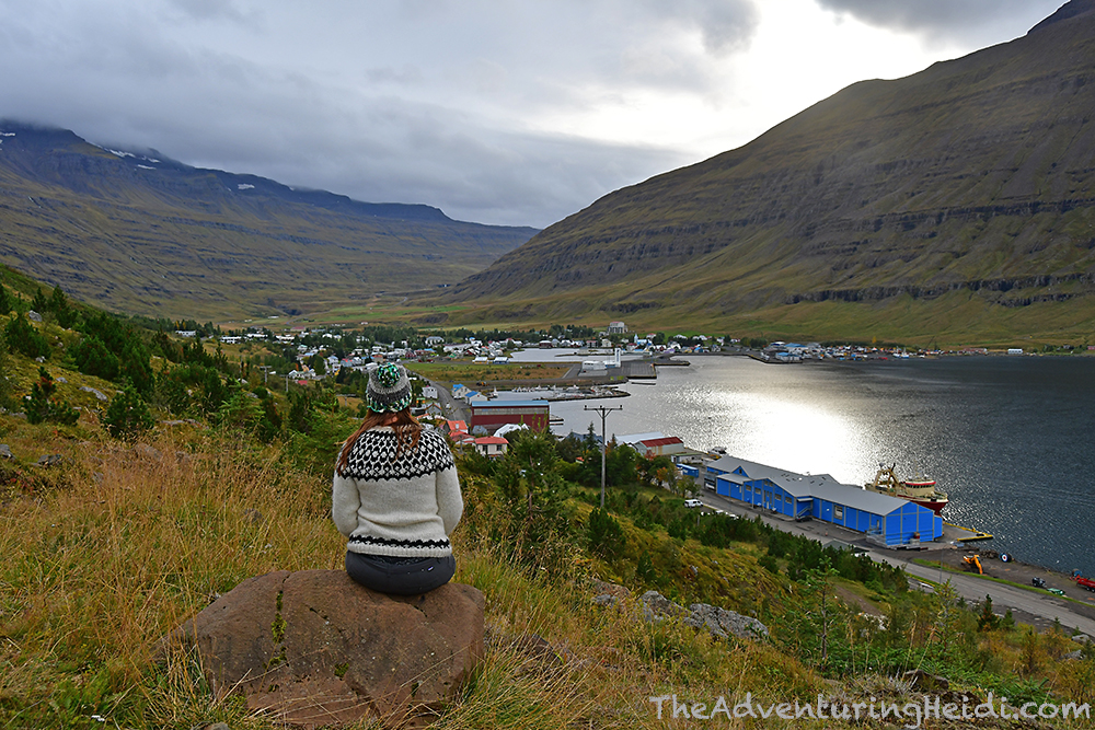
We quickly made our way to the town center of Seyðisfjörður, and parked near the very famous Seyðisfjarðarkirkja, and hopped out to begin our exploring. It was still fairly early in the day, thanks to not being able to stop a lot due to rainy weather, so we decided to explore on foot before driving to a couple of other things and then settling into camp for the night.


Seyðisfjörður is a charming town of less than 700 people. The buildings and houses are colorful and everything is really easy to access by walking. I even found a black sand volleyball court!
We walked back to the van and drove to the trailhead for Tvísöngur, and sighed a breath of relief that the rain had stopped for awhile.

Tvísöngur is a sculpture by Lukas Kühne also known as the “sound sculpture.” It consists of five connected concrete domes, each one designed to resonate a tone of the Icelandic five-tone harmony. It is reached by an uphill (shocking!) trail that is about 0.5 miles in length one way, and connects to several other hiking trails that explore the Seyðisfjörður landscape.


I’m no musician and am completely tone deaf, but had a blast trying to sing inside Tvísöngur. Kubo captured on video my stunning rendition of songs from The Sound of Music, which caused other visitors to cover their ears and run away in horror. Proud of my out of tune singing that was beautifully amplified by the sculpture, I posted the video for my social world to see on Facebook… you’re welcome!
Even if Tvísöngur is not your jam, the scenery is well worth the short hike up to it!
Next up was the “Hvernig gengur?” phone booth sculpture, which was installed to honor the hundred year anniversary of the first international telegraph cable to Iceland, which connected to Scotland. I was kind of sad to discover I couldn’t actually stand inside it and pretend to phone home, but still a fun sight to check out.
By now Kubo had announced that he wanted nothing more in the world than to go to a bar, and pay a silly amount for a beer. So I researched restaurants and menus as we drove to the campground, which is centrally located in Seyðisfjörður and is a short walk from the restaurants. Iceland has a zero tolerance blood alcohol level, so legally you cannot drive after drinking pretty much anything, so it was highly convenient that we could walk to dinner/beers from the campground!

After checking in and parking Carl in the very crowded Seyðisfjörður campground, we changed our clothes and headed out to Kaffi Lára El Grilló Bar. Lára was an infamous resident of Seyðisfjörður who lived in the house that the restaurant and bar is located in. El Grilló comes from SS El Grillo, a British oilship that was sunk by the Germans in Seyðisfjörður during World War II.
Orders are placed at the bar, so we both ordered up tall glasses of El Grillo lager. Kubo selected the leg of lamb, and going against my judgement, I selected the hamburger, emphasizing to the staff that I wanted it cooked “very well done. In fact, burn it.” Kubo expressed shock that I was even risking another hamburger…
After ordering, we picked out a table upstairs and sat down to relax and unwind. When our food came, I once again discovered a very undercooked hamburger staring back at me on my plate (maybe quietly mooing, too). I sighed, and dug in – apparently I did not learn any lessons after my undercooked hamburger in Mývatn. Kubo enjoyed his leg of lamb immensely, and I even had some nibbles! Both of our meals were accompanied by the best baked potatoes anywhere on earth! The large potatoes were soft and buttery and literally melted in your mouth. I don’t know what they were, but they were certainly not the gritty russet baked potatoes we’re use to in the U.S.! And heck, I’ll admit that even my hamburger was good. Overall, our meal was significantly cheaper than our meal at Vogafjós Cowshed Cafe in Mývatn, and way better in taste! To top it off, Kubo had a second beer and I had a slice of chocolate cake for dessert.
Bellies and hearts full, we stepped into the chilly Icelandic night and made our way back to the campground to rest up for the final marathon stretch of our big adventure.

Follow along on our entire 19 day Iceland road trip adventure! Click here for a comprehensive itinerary, with links to each day’s adventure.


Leave a comment