
Iceland Day 5 – September 5, 2018

We awoke early from our slumber, knowing a big day was up ahead. After scooping up our now dry clothes from the bathroom (see yesterday’s post about laundry…), we quickly ate breakfast and hit the road under cloudy skies, destination: the Snæfellsnes Peninsula.
Snæfellsnes is often referred to as “Iceland in Miniature” as it encompasses many of Iceland’s famous features all in a compact area just a few hours from Reykjavík. It definitely makes it a convenient spot to pack in as much as you can for travelers short on time. There’s volcanos and glaciers, waterfalls and black sand beaches, with sheep, horses, quaint churches, and stunning scenery shoved in between. My itinerary for this day was PACKED, but luckily it wasn’t a whole lot of driving, since the peninsula is only 90km long. Here’s to seeing how much we could fit in!

We left Kleppjárnsreykir and drove down Road 50, with the town of Borgarnes as our destination, as that is where we’d turn onto Road 54 that would take us into Snæfellsnes. To get to Borgarnes you have to cross Iceland’s second longest bridge, Borgarfjarðarbrú, which crosses Borgarfjörður. I like Icelandic, because it’s quite a literal language – Borgarnes fjord bridge! Once you begin getting an elementary level Icelandic vocabulary under your belt, it’s easier to figure out what words mean. I realized I had become quite adapt at reading Icelandic in our 19 days, but verbal pronunciation was a lost cause for me.


We didn’t have any reason to stop in Borgarnes, so we kept on trucking along. Our first stop would be the hot pot Landbrotalaug. Iceland was still failing at getting any less beautiful, and it was clear that this day would be one of my highest photo count days of the trip. Kubo drove as I snapped photo after photo from the passenger seat of the dramatic mountains, and road, and lava fields, and everything else in between!


We found the turn off to Landbrotalaug with ease (thanks Google Maps!) and drove down the dirt road. Sadly, it was clear the very small (maybe 3 person max) hot pot was occupied, and several other cars were filled with people waiting their turn. We ate some snacks, used the toilets, and walked around a bit, but with no signs of the people leaving, so for the sake of time we decided to continue on. I would’ve loved a good soak, but didn’t want to wait all morning to do so! This so-called “hidden gem” has obviously become a lot more popular, and it’s probably wise to try to seek out unusual times to get it to yourself.


With Landbrotalaug scratched off our list, we set out to soak up all that Snæfellsnes had to offer! And wow, I must’ve appeased some elves, because the sky cleared up to be a perfect deep blue, the sun shone down, and the temperatures began to rise! This day would end up being our warmest during our trip in Iceland, with highs around 15°C/60°F. Now this might not seem all that warm, but with the intense sunlight, it was definitely a day for breaking out the shorts and sandals… and even hiking shirtless if you’re Kubo! We would also not have any rain whatsoever. Totally bizarre, but totally amazing at the same time to keep all the rain gear packed away. I also had to snicker at all the Facebook travel group posts that warn that “bringing sandals to Iceland is a waste of time.” No, they’re most definitely not! Aside from warm days, they’re handy for hot pots and running around the campground. I’m so happy I had my trusty Chacos for this day!


We drove, stopping when something caught our fancy, which was happening way more than I had expected (in a good way!). One thing on my list of must-dos was the Ölkelduvatn Mineral Springs at the Ölkelda farm. A sign explaining the mineral content of the spring water compared to “normal” water along with a donation box is located by a small parking lot. I’m not one for carbonated mineral water, but Kubo eagerly filled up his water bottle after we tried a small amount in a cup first. Tasted like pure metal to me, but Kubo drank it up.


I’m mostly going to tell today’s tale through photos, as I took a lot of them and this post has a lot of them! So enjoy…


One of our biggest adventures of this day was hiking into the Rauðfeldsgjá gorge. After squeezing Carl into a nonexistent parking spot, we up to to the entrance for a peek inside .This gorge has quite the story behind it (borrowed from the Hit Iceland website):
Rauðfeldur and Sölvi came with their father Þorkell, the half brother of Bárður Snæfellsás who was half man half troll to Iceland as children and lived at Arnarstapi. They often played with Bárðurs many beautiful daughters. One day they lured one of the girls Helga out to an iceberg in an innocent game and pushed her on the iceberg out to the open Ocean. Unfortunately, high winds blew the iceberg quickly from shore and out to the open sea, and she disappeared. The news of her fate and journey on the ice never reached her father as communication were different at that time. In everyone’s mind, she was lost and deceased. Apparently, as the story in the Saga Bárðar Saga Snæfellsás, she reached Greenland seven days later and lived a good live with the family of Erik the Red, father of Leif the Lucky, for many years. In a poem, she wrote and had been preserved in the Sagas; one can sense that she missed her father, family, and country. When Bárður Snæfellsás learned of the disappearance of his daughter he completely blew up in anger, to put it mildly. He grabbed the two brothers, one at the age of eleven and the other twelve, and climbed to the cliff above the ravine. In his uncontrollable anger, he threw Rauðfeldur into the ravine and to enhance the madness he threw the other brother Sölvi of the cliff. Needless to say, both boys lost their lives, but their names have lived as the ravine, and the cliff bears their names; Rauðfeldsgjá and Sölvahamar. After this incident, Bárður lost his mind and eventually walked up to the glacier where he built an ice cave where he has lived for many centuries and according to popular believe, still does to this very day.


We decided to adventure in, pretty amazed at the tall walls and how it kept going and going. There was a part that seemed to involve some bouldering moves, so Kubo set out on his own, and I stayed behind, thinking he’d only be a few minutes. Well, a few minutes came and went and I had been studying the moves of the young teenage boys hustling past me, so I decided to try out some bouldering moves of my own and try to find where the heck Kubo had gone!


I finally found Kubo by a waterfall with a rope along the side of it. He was busy photographing these creepy birds that were feasting on the bodies of their dead friends. Because of the lack of rain gear (about the only time it would’ve been handy today), we decided not to go further into the gorge… and I must admit the cannibalistic birds were weirding me out!


Climbing out of Rauðfeldsgjá is harder than climbing into it due to having to descend slippery rocks. I’m proud to say I made it out with dry feet, though! This was definitely an adventurous time, and I highly recommend it if you’re feeling ok with some of the climbs up rock faces once inside! (I’ve never rock climbed before, and was comfortable with some of the hand holds and what not I had to do, if that helps convince you.)


With growling tummies (seeing those birds eating lunch in Rauðfeldsgjá must’ve made me hungry…), we grabbed a picnic table upon reaching the parking lot in Arnarstapi, and enjoyed our staple lunch of sandwiches and Lays paprika chips in the warm sun. Once we were fed, we set out on the hike along the coast between Arnarstapi and Hellnar. This hike is pretty easy in Iceland terms (meaning it doesn’t go straight up a mountain), and goes along the gorgeous coast line, which is largely basalt columns, and mossy lava fields. Ocean views to one side, glacier views on the other… can’t get any better than that! Though we would turn around before Hellnar since we were going to drive into town anyway, it was a worthwhile couple of miles in the sunshine working on our tans!


Before heading back to Carl, we stopped at the Gatklettur arch, and watched a weasel like critter scurrying across the rocks on the beach (Iceland doesn’t really have wildlife, so we’ll take whatever we find). I somehow completely missed finding the arch in Arnarstapi that you are able to walk and stand on for the perfect photo opp 😦 I’m still sad about this, as it must be in an obvious place since so many people take photos there.
Heading back to the van I snapped the perfect photo of Kubo shirtless with shorts on walking behind two other tourists looking like they were headed on an Arctic expedition with big, puffy down jackets, hats, scarves, and snow boots on. Not posting it here, but still had to share the story. Funny how temperatures can feel so different for different people!

Next stop was a short drive away in Hellnar, where I was on a mission to find the Kcymaerxthaere marker. Kcymaerxthaere is a parallel universe that intersects with our world, or the linear universe. The global project has markers all over the world. I had just visited one in Wyoming a few weeks prior, so I was eager to see one of the Iceland ones, which is “Interdimensional Hopscotch.” I found the marker in the tall grass by Hellnakirkja.


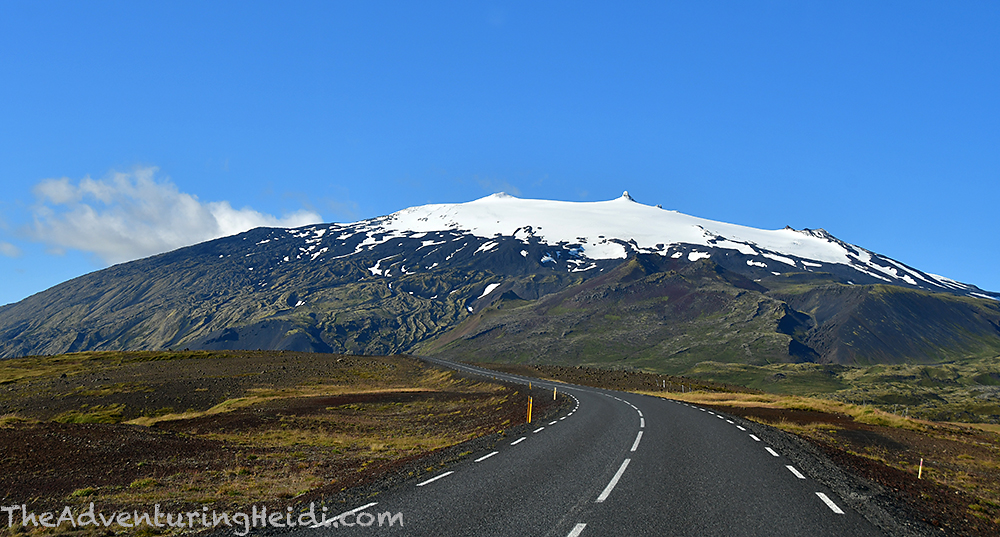
Once leaving Hellnar, and after a quick peek at Laugarbrekka, it was time to enter Snæfellsjökull National Park (Þjóðgarðurinn Snæfellsjökull). Snæfellsjökull is a majestic 700,000 year old, 1446 meter high volcano that stars in the novel The Journey to the Center of the Earth, and is covered by a glacier (though the summit point has been free of snow since 2012.

We made a quick stop for a quick walk around Svalþufa-Þúfubjarg, where we got our first glimpses of the Lóndrangar pillars. Svalþufa is the name of the hill you walk up, and Þúfubjarg is the name for the sheer cliff on the ocean side of the hill, which birds do like to nest on. The sun was not ideal for good photos of Lóndrangar, so we drove down to the national park visitors center, which provided a better view of Lóndrangar, which are volcanic plugs. Numerous hiking paths are in the area, along with the Malariff lighthouse, which was constructed in the 1940s, and a black pebble beach. There is also some playground equipment items, like a small zip line like structure that adult tourists were having a blast with.


As tempting as it was to just sit and enjoy the black peddle beaches at Malariff, we knew we had to keep moving to see everything on today’s crowded itinerary. Next up was the famous black pebble beach, Djúpalónssandur. The drive down Road 572 is through my favorite thing ever, mossy lava fields, ending at a parking lot with bathrooms and lots of signage to point you the correct way. Kubo and I hiked down the Nautastígur path, which leads you through amazing lava formations, and down to the beach. There are a few fresh water lagoons, named Djúpulón, along the way.
I think this is when I had one of my first true “I hate tourists, even though I am one” moments. There was a large group of very noisy men cluttering up the whole path who then proceeded to just trample off trail and start climbing all over things and tossing their cigarette butts everywhere. I swear I hate humans 😦
In 1948, a British trawler, Epine GY7, wrecked off the Dritvík cove and the remains of the ship remain on the beach. Tetanus hazard aside, it adds a bit of something to this black pebbled scene.
One feature of this cool beach is the Aflraunasteinar – Steinatök, or lifting stones. They were used to measure the worthiness and strength of Icelandic fisherman. Naturally, I had to try to see how I measured up, and while trying to lift up the lightest one I fell backwards and sliced my elbow open on a rock. Whoops! I fought back tears with that one. I think a future as an Icelandic fisherman is not for me.


We soaked up some sun for quite awhile on the beach, enjoying the crashing of the waves, and just life in general. However, this wouldn’t be our last beach of the day, so begrudgingly we hiked back up to Carl and continued on our way. Sometimes it’s truly hard to leave such beautiful places behind when in Iceland, but there’s comfort in knowing that another amazing place is just around the corner!
Next up was the Saxhóll crater – more specifically, Litli-Saxhóll, which erupted just a couple thousand years ago. A long staircase leads you to the hike, but the stairs themselves are very shallow, which makes it accessible to a great variety of people. Personally, at 5’10” tall and with long legs, I found them to be rather clumsy to climb, but I appreciate the thought behind them.


Finally it was time to journey to our last big stop on the itinerary for the day – Skarðsvík beach and Skálasnagi/Svörtuloft lighthouse. These two spots are a bit off the beaten Snæfellsnes path, which was half the appeal! We headed down Road 579, heading to the lighthouse first (we’d stop at the beach on the way back). The road soon turned to gravel, and then soon to probably what should not be considered a road after that to get to the lighthouse. Kubo and I both nervously laughed as he carefully drove Carl over the rocks and potholes. Thanks to Kubo’s great driving skills, we made it safely, but I’m sure some low clearance compact rental cars with inexperienced drivers have sacrificed themselves trying to make it out here. Whatever, worth it!!!


Getting our fill of the lighthouse, Kubo carefully drove us back out on the road to Skarðsvík beach. Unlike what Iceland is famous for, this is a golden sand beach, not black! It honestly didn’t seem to fit in with Iceland… aside from the volcanic-influenced geology, it felt like I was more on a secluded beach in New Jersey or somewhere else! We decided this would be the perfect spot to cook up some dinner and watch the sunset.


After watching the sun disappear into the northern Atlantic and chowing down on our broccoli chowder soup, we headed towards the Hellissandur campground, arriving after dark. The back doors of Carl would open up to a magnificent view of Snæfellsjökull from our campsite!
Here at the Hellissandur campground I managed to lock myself in the shower and have a moment of sheer panic! So apparently door locks are different in Iceland, along with washing machines, gas pumps, and shower controls (as I’ve learned in previous days). After I was done showering and changed back into clothes, I went to unlock the shower room door and yet the handle wouldn’t open the door. I jiggled and tugged on it, becoming more frantic with my actions every second. I finally hear a voice from the other side go, “Are you okay, do you need help?” I frantically replied that I was stuck… and naturally as soon as I said that I had done the magic motion with the lock and door handle and it opened. Embarrassed, I shrugged and giggled at the European girl staring at me from the other side. Needless to say, I avoided any locks of that type the rest of this trip… Once again I gave those funny looking electrical outlets a sideways glance in the bathroom, and decided that once again drying my hair wasn’t worth the risk of somehow causing another disaster with my lack of worldliness.
Sleep came easy after a busy, but fulfilling day in the sun! Tomorrow would be a big adventure as we’d board a ferry to the Westfjords!
Follow along on our entire 19 day Iceland road trip adventure! Click here for a comprehensive itinerary, with links to each day’s adventure.


Leave a comment