
Iceland Day 4 – September 4, 2018

Day 4 is when the true adventure began. It was time to hit the road for the next fifteen days and go into the wild, and by that I mean circumnavigate Iceland in a clockwise manner! Though our first three days in Iceland were amazing, I knew deep down that the true adventure laid ahead as we tried to see every nook and cranny of the island that we could. In the rain and dense clouds we hit the Ring Road pointed west, beginning a day of truly chasing waterfalls as we took a crash course in just how many waterfalls there are in Iceland!


We kept on the Ring Road, passing through the bigger town of Selfoss, revisiting Hveragerði, and cruising through the lava fields and moss. We’d skirt the suburbs of Reykjavík, which I have to admit was a bit overwhelming after a few days in small villages and the highlands. I did find it remarkable how smoothly traffic kept flowing at the busy morning hour thanks to roundabouts that everyone knew how to use (roundabouts in the western US sometimes cause more congestion than anything because nobody wants to take the time to understand how to use them).
Our first stop would be the suburb of Mosfellsbær. I refused to go on the trip any longer without a proper Iceland wool sweater, or lopapeysa! Shortly before departing home I figured out Álafoss would be along the route and would be open early enough… woohoo! This store was awesome, and it wasn’t long before I found my dream lopapeysa and resisted buying one in every color. I also picked out a scarf for my mom, wool blanket for my couch (or really my cat… she’d claim it very quickly), and some postcards to send back home. The store was fun to look around as they had a lot of antique wool knitting machines and other items on display. The yarn selection was amazing, and they also sold kits that had all the supplies in it to knit your own sweater if you are so skilled and inclined to do so.


After me forking over tons of dough at Álafoss, we filled out postcards to send out, and then ventured to the Krónan grocery store to restock our supplies. Next stop was the post office, where we discovered it is over $2 a piece to mail postcards back to the US, eek! Yet I still bought extra stamps, because I collect them. Next errand was finding an ATM to take out some local currency, the króna. Iceland is really a cashless society, and I’m not sure we really ran into anywhere that didn’t take credit cards, asides from some coin washing machines. However, I still wanted some cash just in case (and for souvenir purposes). Final errand before hitting the road would be our first fuel stop.
Oh man. You’d think if you’ve worked one gas pump, you can work them all. Well, I suppose that’s true if you never leave the United States. We roll up to the big, “all by itself” diesel pump at the Mosfellsbær N1 station. There’s three nozzles, and we figure out that one is for diesel exhaust fluid. But for the life of us we couldn’t figure out which diesel one we needed to use otherwise. I ventured a guess it was similar to the dyed “off road” diesel in the US that is meant for heavy machinery, but we didn’t know which one was the proper one for a normal vehicle. The gas pump sucks in my credit card, and I enter my PIN, and it tries to select the exhaust fluid and we manage to cancel that order. By now I am on the verge of crying, because I never knew filling up the van would be this big of an ordeal. Kubo, being the rational one, figures something out and we get a bit pumped into Carl. But then it’s not wanting to give us a receipt. I think by now the employees of N1 figure out we were confused tourists. I go inside, holding back tears, and ask for a receipt. Luckily the guy behind the counter is very nice, along with an older manager type. I vented about how I’ve never seen such a confusing situation, and they chuckle. The older manager type deciding to use it as a teaching point, and told us how where we were trying to get diesel was really for commercial vehicles, and instead we need to just pull up where all the cars were, and that there is proper diesel for us there. We thanked him immensely, and pulled Carl up to the proper area and filled him up the rest of the way. Took some guess work and several transactions, but finally the gauge read full! Just when I had thought I researched everything thoroughly before the trip…. yeessshhhhh, I didn’t study how to get gas well enough! (I did have PINs set up on my credit cards, though! That’s a big win!)
And with that… we hit the road!

As we approached Hvalfjörður, we exited the Ring Road onto Road 47, which would take us around the fjord instead of the tunnel underneath it. I’m not much one for driving underneath water, so the scenic route seemed perfect, especially since the hike to the waterfall Glymur was on the agenda. Hvalfjörður means “whale fjord,” but no one really knows why it’s called that. One of the cooler theories involves an elf woman who turned her human lover into an “angry red-headed whale” named Rauðhöfði when he failed to acknowledge their child. This angry red-headed whale, whatever that might look like, lived in the fjord and would wreck ships and cause havoc. Sounds legit to me! Oh, and the only existing whaling station exists here, too. But I’m sticking with the angry red-headed havoc-causing whale story.
The drive around Hvalfjörður is quite amazing. I get that people wanna save time, and the tunnel thing is convenient, but I’ll take these big, steep mountains, neon green plant life, and winding roads any day! I was snapping photos like crazy from the passenger seat the intermittent sunshine shone between sheets of rain.


I think it might have been this day the “Waterfall Game” came into being. It’s really a game with no winner, and really one simple rule: Yell out “waterfall!” every time you spot a waterfall (or “wasserfoss,” which is Kubo’s weird German-Icelandic hybrid word he started yelling). Any size and shape was fair game. You’d think a few weeks in we would’ve stopped this silly tradition, but nope, we did it up until our very last waterfall sighting! Water just seems to pour out of every crevice in Iceland, and personally, I can’t get sick of waterfalls… in fact, I’m horrified when people say they get sick of waterfalls in Iceland… like… how?! But I digress… the Waterfall Game. I’m pretty sure born on Day 4, if not, solidly born on Day 5. Sometimes “waterfall” or “wasserfoss” was literally the only word said for minutes at a time, over and over repeatedly without much stopping. You should try it, it’s a fun game!

I was being pretty strict with the itinerary, but that is where my other half comes in to same the day with just doing random things, like pulling off onto unmarked, unnamed dirt roads and seeing what’s down them. That’s how we found an awesome unnamed, double waterfall in Hvalfjörður!


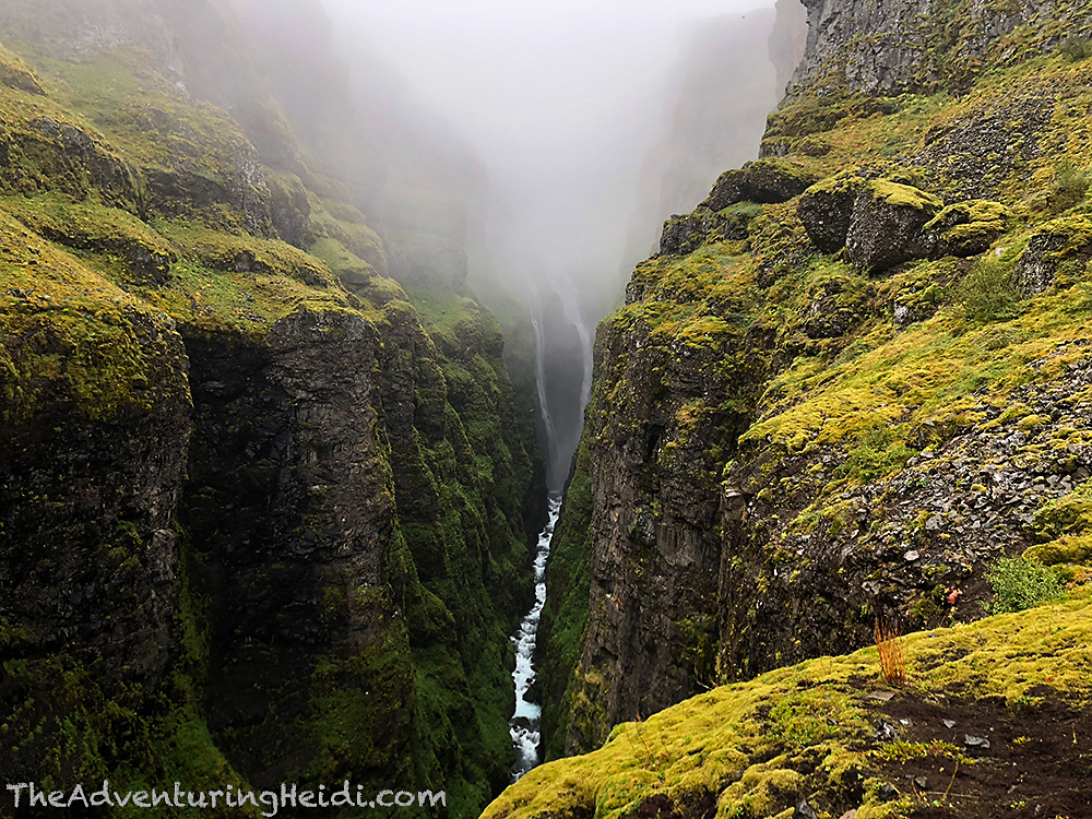
Slight detour behind us, and a few roadside waterfalls later, we pulled onto the gravel road that leads to the Glymur trailhead in the Botnsdalur valley. Glymur once was Iceland’s highest waterfall, with the river Botnsá dropping 198 meters down the side of Hvalfell into Leggjabrjótur gorge. This was before climate change and melting glaciers revealed Morsárfoss pouring down from Morsárjökull at a height of 228 meters. But since Morsárfoss is a wee less accessible than Glymur, I’ve dubbed Glymur “the highest easily accessible waterfall in Iceland.” Because second place is the first loser, and I wasn’t hiking to a loser waterfall this day!
First up was a good lunch to fuel us for the hike, and the donning of rain gear since the weather had been off and on rain all day. We weren’t exactly sure how much of Glymur we’d be able to see with the low cloud cover, but there was no other way to find out except to start hiking!

The trail starts out pretty easy, and is well signed and worn in (so hard to get lost really, and you can always follow people, too). All around, lush green plants surround you, with a few shrubs beginning to show their autumn colors. Waterfalls dot the landscape as other streams pour into Botnsá. Because the ground is always muddy in Iceland, the trail can be mud, and muddier at times. This was a good day to test our our hiking boots and rain gear, and once again they were up to the task and kept us completely dry! (I cannot state the importance of proper hiking boots and rain gear in Iceland enough!)

The hiking trail to Glymur is honestly one of the most unique hikes I’ve done with it’s scenery, cave, and river crossing. Cave? Why yes, the Þvottahellir cave! Though is it more like a tunnel? Hmm… either way, a fun way to make an exciting hike more exciting!

Up next was the crossing of Botnsá. In the summer months, a log is installed to help assist with the crossing of this fast flowing river, and there is a guide cable to hold onto as well. Telling from the pile of discarded wet socks on either side, many people must leave with wet, bare feet while trying to cross. We did notice some people walk up, take one look at the crossing, and turn back. Though I fear water like nothing else, I wasn’t going to let it deter me. Kubo went first, demonstrating the path across the rocks to the log. I was a lot less graceful, and I held onto that cable for dear life, but I made it safely across to my relief, and with dry feet and socks still in place!

Now the fun would be begin. I read that the hike was steep, but nothing on the internet does justice to the Icelandic trail building method called “Go Straight Up the Mountain.” The Glymur hike throws slippery rocks into the mix with some steep exposure to the river below. Luckily there’s some ropes and chains to hold onto if needed. I actually quite enjoyed the steep scrambles, but this is definitely a hike for those prepared and with a bit of stamina and fitness.


We made our way to Steðjasnös view point, and then up to the Hellupallur viewpoint. Obviously the trail continues, but with the clouds, there wasn’t more to see, and I was hesitant to be in the thick clouds on the side of a cliff. It was still very beautiful even though we couldn’t see most of Glymur. The clouds and rain added a mystique to the already magical landscape.


With the rain falling pretty hard, we began our descent back to the trailhead, stopping along the way for some fresh water and more photo opps.


The river crossing went much faster for me this time around and I wasn’t nearly as intimidated!


2 hours and 40 minutes later (and 3.31 miles), we were back at Carl. We stripped off our outer layers of rain gear, and hit the road with more waterfalls as the destination before settling into camp for the night.


To get to Hraunfossar and Barnafoss, Google Maps had us turn off on Road 520, which is gravel and saves some miles. I don’t think we passed a single vehicle on this short cut! Kubo and I were all about getting off the beaten path on this trip, so we took delight in the fact Google read our minds and sent us on this beautiful short cut!


After enjoying our short cut, we turned onto Road 50 and then 518 to head towards Hraunfossar and Barnafoss, our final two waterfalls we’d chase for the day.

Hraunfossar is a series of waterfalls that stream out of the Hallmundarhraun lava field over the course of about 900 meters in the Hvitá river. Hraunfossar is a truly unique waterfall, as it seems like the water is appearing out of nowhere from the ground! It’s also very hard to photograph because it’s so long, so luckily cell phones with panorama features saved the day! There a walking paths and viewing platforms so you can get a good look from several angles. Hraun is the Icelandic word for lava, so the name literally means lava falls. Makes sense!


Just a stone’s throw away is Barnafoss, or childrens falls. Legends goes something a bit like this:
“Many Icelandic folk tales have been associated with Barnafoss, the most famous being about two boys from a nearby farm, Hraunsás. One day, the boys’ parents went with their ploughmen to a church. The boys were supposed to stay at home, but as they grew bored they decided to follow their parents. They made a shortcut and crossed a natural stone-bridge that was above the waterfall. But on their way, they felt dizzy and fell into the water and drowned. When their mother found out what had happened, she put a spell on the bridge saying that nobody would ever cross it without drowning himself. A little while later, the bridge was demolished in an earthquake.”
I’ve also heard the version where the mother destroyed the bridge herself. Either way, the stone bridge was destroyed . This falls is actual kind of terrifying when you look at it, the water seems so violent as it churns through the narrow canyon.


After our fix of waterfalls for the day, we turned back to journey to Kleppjárnsreykir where our campground was located for the night. However, I can’t resist historic Icelandic churches, so we stopped in Reykholt, where I discovered the hot pot that had been on my original agenda before I realized people were not allowed to bathe in it!

Reykholt was the home of Snorri Sturluson (1178- 1241) in the 13th century, one of the most famous Icelanders of all time. He was a poet, politician, Saga writer, and one of the richest men in the country during his time. Needless to say, a lot of the “stuff” in Reykholt involves him, rightfully so. There is a school, museum, cultural center, statute, and two churches on the the grounds. It’s a short walk around to see everything.


After Reykholt, it was just a short drive to Kleppjárnsreykir, where we would be staying the night at the Hverinn campground. Hverinn was quiet, and I think there were only 3 other campers aside from us. After carefully picking our spot to park Carl, I set out to do laundry, which turned into a bigger adventure than I was expecting. I have never seen a washing machine have so many symbols on it! After some guess work, and poking enough buttons, I closed the door to the washer, hoping it really was set for cold water and hoping my clothes came out okay. Meanwhile, Kubo was cooking up an amazing dinner on the patio area of the Hverinn restaurant/reception building of chicken cordon bleu, baby red potatoes, and broccoli.
We got a taste of our first clear Icelandic sunset as the sky turned orange and pink, and the rain seem to life. The owner of Hverinn (well, I’m just assuming he owns the place!) came out to smoke and we chatted for awhile about Iceland’s crazy cold and rainy summer, and how back home in the US we saw a lot of wildfires. He told me about how he really wants to visit Aspen, CO, one day, and we talked about how the forests are managed in the US. He agreed he’d send me the rain next time to help out with our drought conditions!


Luckily the clothes came out of the washer okay. The dryer was another story. I’m pretty sure it was older than me, as I’ve never seen a contraption like it before. After an hour or so, our clothes were still as cold and wet as they were coming out of the washer. Kubo took over the women’s bathroom (laundry was located in the women’s room) with all our clothes creatively hung out so they would dry. Luckily the room was heated very well. I was worried this would annoy the other travelers, but then we realized most of them were in massive RV’s that had their own bathroom facilities (and the people never even came outside). I still fretted a bit, half worried someone would steal our socks and underwear, and the other half that we would get in some sort of trouble. I went to check on the clothes around 10:30pm, and as I came out of the bathroom I looked up and saw the most glorious thing – the Northern Lights!!
I quickly ran back to the van and Kubo and frantically grabbed my camera and screamed at Kubo to get the tripod. In my haste, I forgot to focus the camera lens when I switched it to manual mode, so all my photos would come out unfocused. Not really an issue for the aurora itself, but the stars/trees/anything else looks like the world when I don’t wear my glasses – whoops. The aurora was particularly strong this night, and we could make out the green colors with our eyes as it danced and swirled right over our heads (normally the aurora appears almost cloud-like and looks white and gray to the naked eye). Literally one of the most magical moments of my life!
Iceland, you’re cool!
I’m going to end this post with a whole slew of out-of-focus Northern Lights photos! Because there is no need to properly focus your camera when these magical things are dancing above your head!


Follow along on our entire 19 day Iceland road trip adventure! Click here for a comprehensive itinerary, with links to each day’s adventure.


Leave a comment