
Travelers to Wyoming tend to know/do the “big three”: the Tetons, Yellowstone, and Devils Tower. However, Wyoming does have a few additional National Park Service units that are worth exploring, and often with a fraction of the crowds!
That’s right, Wyoming is home to seven NPS units, not including the National Historic Trails that cross-criss the state! Aside from the famous ones mentioned already, there are:
- Fort Laramie National Historic Site (I visited in May 2022)
- Fossil Butte National Monument (I’ve visited briefly a few times, but not in depth enough to justify blogging sadly)
- John D. Rockefeller, Jr. Memorial Parkway (smooshed between Grand Teton and Yellowstone National Parks, so visited plenty, but people might not realize it)
- Bighorn Canyon National Recreation Area
With six NPS units nabbed, I wanted to finish off Wyoming, so when life took me near Bighorn Canyon National Recreation Area, I knew I’d have to find something to give me a taste of this wonderful area!

Bighorn Canyon NRA was established in 1966 after the construction of the Yellowtail Dam on the Bighorn River. The area straddles the Wyoming-Montana border, and has two distinct districts that are not connected. In fact, it takes something like three hours of driving to get from the south to north district!
The North District in Fort Smith, MT is mostly water based recreation and includes:
National Park Service
– Yellowtail Dam Visitor Center (Open Memorial Day to Labor Day)
– Park Headquarters
– Ok-A-Beh Marina (Open Memorial Day to Labor Day)
– Afterbay Reservoir, Boat Launch, and Campgrounds
– Three Mile River Access
The South District in Lovell, WY is largely land based recreation and includes:
– Cal Taggart Visitor Center (Open year round)
– Horseshoe Bend Marina (Open Memorial Day to Labor Day)
– Devil Canyon Overlook
– Pryor Mountain Wild Horse Range
– 12 hiking trails
– Four historic ranches open to self tours
– Horseshoe Bend, Barry’s, and Trail Creek Campgrounds
I was in Lovell, so I figured out a few stops in the South District to kill an hour or so of spare time.
And geez, I almost dived into things without a geology lesson! The canyon itself was formed as the Bighorn River, which flows north from Wyoming, sliced through uplift crust of the Bighorn and Pryor Mountains. 500 million years of Earth’s history is exposed along the Bighorn Canyon’s walls, which can reach 2000 feet deep. Strata include sandstone, mudstone, gypsum, shale, limestone, dolomite, calcareous shale, and metamorphic rocks. You, however, mostly see limestone.
The Yellowtail Dam created the 71-mile long Bighorn Lake, and 55 miles of the lake is in Bighorn Canyon (which is the third longest canyon in the United States!). Taking Wyoming State Highway 37 north gives you a chance to see some of the canyon from land. But if you ask me, I can only imagine it is absolutely spectacular to boat or kayak the canyon! There are several boat-in campsites along the canyon, along with spurs like the Black Canyon.
First up was the Cal Taggart Visitor Center, which is in Lovell. I had been here in 2019, but I wanted a repeat visit to get my Junior Ranger badge, passport stamps, and shop for a souvenir patch. Ranger Nate was absolutely fantastic, and we chatted quite awhile about various travels, Chick-fil-A, and the crazy world of avid NPS passport stamp collectors. He watched me, chuckling, as I rummaged through a box of expired and retired passport stamps, trying to confirm a date range of a “Lost Forever” stamp that might’ve been found and my resulting post on the National Park Travelers Club forums to confirm it was the missing stamp.

I wish I would have had time to check out a few of Bighorn Canyon’s seventeen miles of hiking trails such as Sykes Mountain, but hot midday temperatures and a time crunch did not lend itself to hiking (and the whole I couldn’t get all sweaty and gross thing as well). Instead, I chose Devil Canyon Overlook, which provides amazing views of the Bighorn River 1000 feet below from a paved path.

It did not take very long at all to reach the Devil Canyon Overlook. And despite it being the height of tourist season in Wyoming, there was only one other car! There is a paved path connecting various viewpoints over the canyon, along with informational signs.

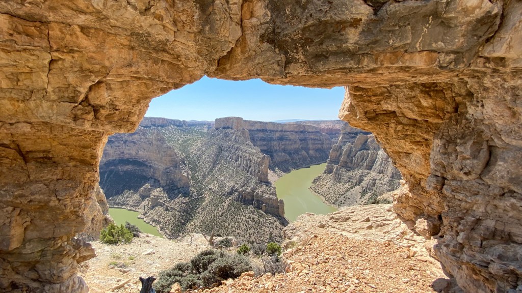
I had seen many photos of the canyon taken through a natural arch, but not a lot of information about how to find the arch aside that it was south of the Devil Canyon Overlook parking lot. To my surprise, I easily found the arch, and enjoyed a fairly sketchy descent down to it in my Birkenstocks. So worth it! 😀


After exploring the scenes and wishing I was on a kayak, I ate some tuna salad quickly in the car before heading back to Lovell. I mused in my head about how many amazing things are in Wyoming, my home state, that I really was unaware of – Bighorn Canyon being one of these things. I definitely hope one day I can return for a bigger adventure! Maybe even one by water!

I want to acknowledge that Bighorn Canyon National Recreation Area is on the traditional territory of Apsáalooke (Crow) (Link 1), Tséstho’e (Cheyenne) (Link 1), and Očhéthi Šakówiŋ (Link 1). Much of the unit is surrounded Crow lands, and entry to these sacred tribal lands is prohibited to non-tribal members.


Leave a comment