
Iceland Day 15 – September 15, 2018

And so begins our final big stretch along the popular south coast of Iceland!
The south coast. It’s busy, it’s crowded, and it’s where all the tourists want to go. For people like myself that prefer solitude and getting off the beaten path, sometimes the initial instinct is to dislike something due to its popularity. But one simply cannot do that with Iceland’s south coast. It’s famous and popular for a reason… it’s downright amazing! Sure, the throngs of tour buses, disrespectful people, and annoying buzz of drones can be hard to handle if you prefer solitude, but Iceland is there in all its glory to remind you to breathe, look around, and ignore the idiots (after you make a futile attempt at lecturing them on Leave No Trace). It is kind of liking climbing 14ers in Colorado… it’s a cliche thing to do, especially on the more “easier” climbs, but it’s so awesome that even the grumpy people-hating people find themselves doing it. And after all, I was still one of the crowd, flocking to Iceland (though I’ll put up a good argument that I went for more than a good Instagram photo or to capitalize on travel blogging).
We set out from Stafafell campground under cloudy skies, skipping breakfast in hopes of getting to Stokksnes before it got too busy. Our original plan had been to make it there for sunrise, but clearly we had hit snooze a few times on our alarms and that didn’t happen.

But first… the big Red Chair! Yes, a chair… bolted to a rock alongside the Ring Road. I’ve dubbed it one of the World’s Most Scenically Located Chairs. Fun for a few photos before continuing on our way.


We continued on the Ring Road, ducking into the short Almannaskarðsgöng before emerging with sights of Vatnajökull glacier tongues teasing us. I became downright obsessed with glaciers during this trip, so I’m betting I made some sort of excited squealing sound as we quickly turned onto the road to Stokksnes after the tunnel.


Upon arriving at Stokksnes we stopped in at the Viking Cafe, and after seeing the breakfast buffet, we decided to splurge and eat someone else’s skyr, and not our own on this morning. The owner of Viking Cafe gets a lot of grief for some reason (as evidenced by the tourist yelling at him while we ate, and then finding profanities written in the sand out on the dunes directed at the owner), but we found him pleasant and nice enough. Perhaps people are spoiled by the lack of admission fees at nearly everything in Iceland, but hey, it’s private land, and I don’t blame them for having an admission fee! US National Parks are what, $25+? Yeah, I’ll pay the less than $8 USD (800 ISK) for Stokksnes.
The breakfast buffet was a traditional Icelandic spread of various meats, veggies, skyr, bread, coffee, and cakes. We took our time eating, letting the coffee perk us up for the day ahead before traveling on down to take in the famous views of Vestrahorn. I kept eying a dark grey lopapeysa for sale, but ended up resisting the impulse to buy a third one on this trip. We slid our admission ticket in the gate, and proceeded out on the black sand road that is seen in like every drone video ever taken in Iceland.


After getting our fill of exploring the tall black sand dunes near the end of the road, we drove a bit further back so we could attempt some of the “walking on water” shots that have become popular here. Seawater gets trapped on Stokksnes, and remains rather shallow, so one can walk quite a ways out on it. Unfortunately we visited on a windy day, so there were not perfect reflections happening, but cool none the less. I actually found it to be a bit unnerving walking in the shallow water, as the waves made me feel dizzy. I failed at doing some yoga poses, Kubo failed at getting photos of them, we had some chuckles and enjoyed this pretty crazy corner of nature.


A quick bathroom stop back at the Viking Cafe, and we continue on our way, making another stop at a viewpoint. Another traveler pointed at my camera and commented that I must be a “serious photographer,” so I chatted with him about my history as a photographer for automotive racing and explained why my lens hood was covered in zebra duct tape (I did it originally to tell my equipment apart from others and make myself stand out, as if a female car racing photographer doesn’t already stand out, ha!). Gotta love random roadside chats along the northern Atlantic Ocean!

Though we hadn’t been awake for all that long, we felt we well deserved a nice hot pot soak, so we turned down Road 984 to head to the Hoffell Hot Tubs, getting a nice view of Hoffellsjökull as we drove along.


The Hoffell Hot Tubs are five tubs filled with varying temperatures of water that are tucked up next to an interesting rock feature. They use to be operated on an “honor box system,” but there was a reception trailer in place and 1000ISK fee (less than $10 USD) to use them. There are indoor changing rooms and two outdoor showers. Kubo and I changed into our swimsuits in the van and then jumped out for some warm water goodness.

We tried a few of the different tubs before settling on one with our ideal temperature. I quite liked the idea of soaking with a glacier view, but found the tubs on the other side of the rock from the glacier to be a better temperature. Continuing with our hot pot tradition, we chatted up two German travelers who were road tripping in a Subaru Forester (yay for Icelandic Fozzy!). We swapped travel plans, and had an overall nice chat. Still have to laugh at how nearly every time we made single serving friends on this trip, they were from Germany!

Though it would’ve been easy to just stay soaking in the amazing water all day, time was a-ticking and weather looked like it was moving it, so we sadly bid farewell to our last Iceland hot pots of the trip, showered, and changed so we could head towards Jökulsárlón.


It’s hard to know how one should feel about Jökulsárlón. On one hand, it is a beautiful nature wonder, with blue icebergs jaunting out to sea with the glacier at the distance head of the lagoon. On the other hand it is real-life proof of climate change, and how rapidly it is in occurring. Breiðamerkurjökull use to sit practically at the edge of the Atlantic Ocean as late as 1948. In last 60+ years the glacier has retreated nearly a mile away from the ocean, forming what is now Iceland’s deepest lake. The lagoon has increased in size four-fold since the 1970s alone. At the rate of current retreat, it is believed a deep fjord is going to replace where the glacier use to be, and the Ring Road bridge is under threat. So yeah… it’s hard to feel completely happy about seeing Jökulsárlón with knowing why it exists in the first place.
We opted to go across the bridge and explore Diamond Beach on the west side before checking out Jökulsárlón more. It was trying to rain off and on, so raincoats were donned and we hopped out into the crowds. Diamond Beach is simply the name given to the shore were icebergs and smaller chunks of ice from Jökulsárlón wash ashore. It can look different day to day, and probably even throughout the day due to the tide.


Getting our fill of Diamond Beach, we traveled back over the sketchy one lane bridge and parked in the lot for Jökulsárlón. Holy mass tourism/tour bus hell! It had started raining super hard, so Kubo and I hung out in Carl for a bit before deciding to dash to the bathrooms.
OK. Here’s my Iceland bathroom story I am so proud of. I know *some* out there might not approve, but I like to preface it with 1) I have no patience for long lines, and 2) it’s a just bathroom and a natural human function. The women’s bathroom had a really long line, the men’s did not have one. Kubo popped in and found an empty stall in the men’s bathroom, and waved me in, so I hopped out of the women’s line, strutted my stuff through the men’s bathroom to the stall, did my business, and strutted back out to the confused looks of the men inside. An older British lady, upon seeing my genius idea gave me a huge smile, and proclaimed, “If you did it, so will I!” and strutted her stuff into the men’s bathroom.
And that is my story of using a men’s bathroom in Iceland, and inspiring a British woman to do the same.
Anyways…
The rain continued pouring down, so we dressed in our full rain gear and headed out into the downpour. We walked over to the information sign, read the depressing story of glacier retreat, and then walked to some higher viewpoints before continuing down to the shores of the lagoon. We spent a decent amount of time watching the various tour boats jetting around the lagoon along with kayakers, and some seals. The rain wasn’t exactly the funnest experience (I mean, it was coming down hard), but it’s all about making lemonade in a place like Iceland where the weather doesn’t always play nicely.


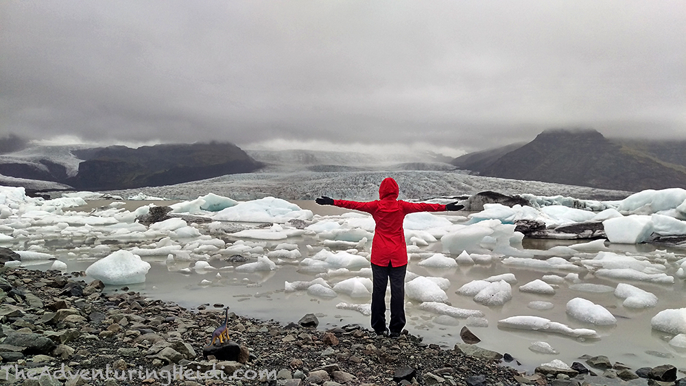
Though Jökulsárlón was cool, I really was eager to get to Fjallsárlón, a smaller glacier lagoon just down the road from Jökulsárlón (you can hike between the two actually) with a closer view of it’s glacier, Fjallsjökull, and a little less people.
Though the rain was less crazy as it had been earlier , it was still raining as we stepped out of Carl. This time I tucked Dino, my traveling brachiosaurus under my arm, and left my DSLR in Carl (iPhone with LifeProof case just likes the rain a lot better). It is a short hike to get to the lagoon, in probably the mildest uphill gradient we had seen yet in Iceland.


We spent considerably more time at Fjallsárlón, taking photos with our traveling items and ourselves, and we were able to go around a slight corner to get the feeling that we had the place all to ourselves (except for the irritating drone overhead…).
After some lunch, we continued on in the rain, with clouds hiding most of the views.

Iceland is really great about having amazing signage that points you to various things. We saw a sign for Kvíamýrarkambur, and Kubo turned down the muddy road (that you could argue wasn’t much of a road, more of two track through moss fields). Though it looked like it lead somewhere great, we turned around, not wanting to risk getting stuck in Carl. Turns out it leads to a very unknown glacier lagoon for Kvíarjökull. Damn you, weather!


Because rain and clouds really obstructed many of the views of Öræfajökull and Hvannadalshnúkur (Iceland’s highest point), we headed more and less straight to Svínafellsjökull. Apparently I didn’t quite do as much research as I thought I did, as I assumed this was one of the glaciers you could walk right up to, but I think the one I was thinking of was really Sólheimajökull, much further west. Needless to say, we were still on our way to see a glacier, yay!

After a fantastically bumpy 2km drive, we arrived at the small parking lot for the trailhead of Svínafellsjökull. Warning signs are plentiful, and there is a memorial plaque for two German travelers who went missing in this area in 2007.

Upon seeing the large lagoon and realizing the trail seemed to stay above the lagoon and glacier, my heart sunk realizing that we wouldn’t be able to touch the glacier (at least not with an easy walk) and that I had failed on this part of my trip research. However, we continued past the main viewing area, taking the small trail that hugs the cliff above the lagoon. I was so happy to be seeing a glacier this close that my mood lifted!


We continued on until both Kubo and I no longer felt comfortable on the loose, narrow trail. I do not like exposure, especially above freezing glacier melt water (and I’m a clumsy person by nature), so I felt I had reached my limit. We sat down and enjoyed the views over Svínafellsjökull, and over the lagoon out towards the ocean. Everything about our Iceland trip had been cool, but this definitely makes my list of Top Cool Iceland Moments!

After hiking back to Carl and another 2km of jostling around on the road out, we backtracked slightly to the Svínafell campground, our home for the night. This is a very lovely campground complete with a waterfall, sheep, and lovely facilities. I took to cooking up spaghetti for dinner. This was probably one of our worst weather days of the trip, but still was a great one with all the glacier chasing!
Follow along on our entire 19 day Iceland road trip adventure! Click here for a comprehensive itinerary, with links to each day’s adventure.


Leave a comment