
Iceland Day 2 – September 2, 2018

The sound of hard rain on the camper van roof greeted me when the alarm went off in the morning. This wasn’t any sort of pleasant rain from the sounds of it, and I tried to remind myself not to panic as the weather in Iceland changes so quickly. We wiped the sleep from our eyes, refreshed from a solid eight hours of sleep. I pleased to realize that I did not feel any jet lag at all, although we had jumped six hours into the future. We putzed around the van, getting dressed, and having our first breakfast. And wouldn’t you know, there was blue sky peeking through a rainless sky by the time we emerged from Carl!
Our first full day in Iceland was to be dedicated to the “Golden Circle,” or at least my version of it. The Golden Circle is probably the heaviest tourist-trafficked area in all of Iceland thanks to its proximately to Reykjavík and the international airport. Initially my itinerary had us skipping the traditional route in favor of visiting Gjáin and Háifoss, especially when word got around that the hiking path to Brúarfoss had been closed. However, a few weeks before departure I came across some YouTube videos that made it clear that maybe the road to Háifoss wasn’t the best idea to attempt in our camper van, so I redid the Golden Circle day. We would still end up skipping Geysir and Gullfoss due to time, but hey, we already decided by this point that we were coming back!
We set out from a soggy Hveragerði and headed east on Route 1, or as it’s infamously know, the Ring Road. We quickly came upon our first speed camera, which Icelanders politely warn you about with a large sign announcing it’s up ahead (how tourists still manage to get speeding tickets is beyond me… come on, they tell you about the damn cameras!!). We quickly turned onto Route 35 and saw the first Icelandic horses of the trip! “Pull over!!!” I screeched in excitement.
Icelandic horses are small (but don’t dare call them ponies), friendly creatures with amazing hairstyles. They even grow fluffy coats in the winter time! Though the ones we pulled over to see were too far away to pet, I still grabbed some good photos and knew it wouldn’t be the last time we would be seeing them (though they are more rare than the ubiquitous sheep).

Iceland gets a bad reputation for not having any trees. I mean, sure the settlers did a good job at chopping most of them down, but there are indeed trees in Iceland. Just as many as I’m use to seeing every day in Wyoming, so I don’t find the “treeless” landscape as treeless as others do. Route 35 to our first stop was beautiful, with trees and summer cottages dotting the landscape. The scenery seemed very “Nordic” to me (whatever that means), and also like a place I’d like to set up house in and never leave. I became aware that we were at quite a high latitude, and this could be seen in the plant life. It all seemed small and hardy, which I’m guessing you have to be to survive on very little daylight hours for months. We also saw several areas where reforestation has begun, easily spotted and identified due to the fact all the trees were planted in orderly, straight lines.

Our first stop for the day was Kerið, a 3000 year old volcanic crater lake that is believed to have formed after a cone volcano collapsed. Kerið is also famous because Björk performed a concert in the middle of it (can I just say that seems so damn Icelandic of Iceland to do?!). After paying our 400 ISK entry fees (little less than $4), we set out along the hiking paths that circle both the top and bottom of the crater.


We circled all the way around the top, and then descended the stairs to get to the bottom. As I was posing for photos on a bench, a very nice French traveler with impressive Nikon gear (photo geeks tend to notice those things…) asked if it was okay to also photograph me, and was nice enough to grab a photo of Kubo and I together. Though the water looks to be an opaque blue, it actually is surprisingly clear when you view it up close. Super clear water was about to become today’s theme!
Google Maps directed us to continue on Route 35 and then to turn off on Route 351 to make our way over to Þingvellir National Park. This would be a mostly gravel route, but a nice detour “off the beaten” path.


Finding unexpected things to stop and see is the majority of the fun of a road trip. Though I had a crazy detailed itinerary planned, it just wasn’t possible to account for everything that we would encounter, especially since most blogs and websites are focused on the main attractions. Once on Route 36, we came across the Ljósafossstöð, a hydropower station utilizing Ljósafoss on the Sog River. Since it was a Sunday, it appeared everything was closed, so we snapped a few photos and read up on the visitors’ sign about the plant.


We left the power station, and continued on Route 36, skirting the shores of Þingvallavatn, which is Iceland’s largest lake. Due to road construction, we had to turn onto Route 361 to reach Þingvellir National Park. 361 starts out pretty narrow, one lane in fact, for two lane traffic. Luckily there’s pull offs you can utilize to let oncoming traffic by. I really liked this route since it went around the lake, with plenty of pull offs for picnicking and parking. However, it was obvious that the amount of traffic had increased significantly from the other locations we had been so far in Iceland. Yep, we were about to land in the thick of one of the most visited spots!


Þingvellir National Park is significant for geological, historical, and cultural reasons. Geologically, it is a rift valley that marks the crest of the Mid Atlantic Ridge, and boundary of the North American and Eurasian tectonic plates (yep, you’re in the middle of two continents!!). Numerous fissures and faults are in the area, due to the plates moving away from each other at about 2.5cm a year. To boot, Iceland is the only place you can see the Mid Atlantic Ridge above water! Historically, the area was the site of where the first parliament, or Alþingi, was established in 930 AD, and over the centuries has been an important part of Iceland’s national identity.
We parked at the Öxarárfoss Trailhead, and began our descent down into Almannagjá, a canyon that marks the eastern edge of the North American plate. I dunno about you, but I find it pretty cool that this trip took place on technically two different continents! We walked along, first stopping at Öxarárfoss, where we joined the throngs of people to get our photos. I must admit, I’m not one for crowds, so seeing the parking lots full of tour busses wasn’t pleasant, but luckily the park is big enough to kinda spread everyone out. Þingvellir ended up being a lot cooler than I had anticipated, and we explored longer than I had planned (hence why Geysir and Gullfoss would get scratched from plans later in the day). The walking paths are very well marked with distances to each sight.


Numerous fissures are all over the place, and are filled with brilliantly clear water. You don’t realize how clear water can get until you see it in Iceland, believe me! It seemed like you could see forever down these fissures. You can go diving and snorkeling in one of the fissures, but it wasn’t on the itinerary for us (I also hate putting my face in water so… that kinda messes up a snorkeling plan).


We looped around to Þingvallakirkja, which was built in 1859. Getting a clear photograph was quite challenging, mostly in part to Kubo who wouldn’t move out of the frame! I cropped him out of the photo below, ha! Next to the church is a building that I can’t figure out what it was/is and a small cemetery.

We continued on the walking paths in the direction of Þingvallavatn before turning to head back to the trailhead and to see a final few attractions. Overall, all said and done, we’d cover 3.4 miles in a little less than 2 hours according to my Garmin. Well worth the time spent!

Next sight was the Drekkingarhylur, or “Drowning Pool.” From about 1565 to 1734, the Alþingi carried out death sentences, and women were sentenced to drown at this site. Usually the women were accused crimes such as bearing children out of wedlock, incest, or other sex-related crimes. Women who were sentenced to die had a bag put over their head, and then were pushed into the pool and held down with a stick until they didn‘t move anymore. Quite the…. hrmmm… tale?

Next up was Lögberg, or “Law Rock.” This is where the Alþingi would assemble… maybe. The exact location actually isn’t known, especially since the geology of the area is ever changing. But I’m okay with rolling with this as the location!


We made our way back to Carl, back through the rift, and up the rocky stairs back to North America. Our little walking excursion worked up an appetite, so while heading back on Route 361 we looked for a pull off to have a quick lunch. We found a gorgeous spot not too far off the shores of Þingvallavatn, and even the sun came out! We fixed up some very delicious sandwiches, and I even enjoyed a can of Appelsín, which is orange soda and the only Icelandic soda there is (I think). Appelsín is quite addicting, even for me who rarely drinks soda otherwise. I can’t explain it, but it’s simply the best orange soda I’ve ever had.


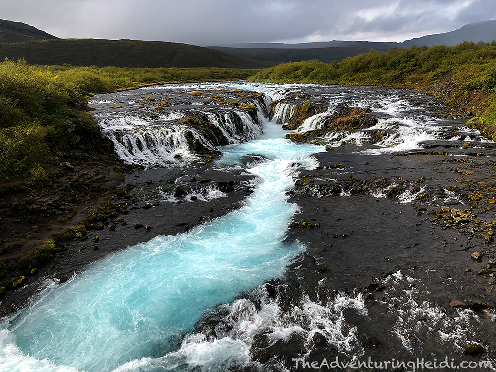
Bellies full, we hit the road headed east, traveling through Laugarvatn (home to a nice geothermal spa that we didn’t visit) and all the pretty sites and things before crossing the Brúará river and pulling into the public parking lot for the hiking trail to Brúarfoss. This waterfall had captured my imagination after I had an old cycling teammate visit there a few years earlier. It doesn’t look like your typical waterfall, and has a very unique blue color to its cascading waterfall. It quickly made my List of Things to Do in Iceland. However, I had a scare in July when news broke that the homeowners near the falls had closed off access to the falls. So I sadly took it off my list, until a few weeks before we were leaving when word got around that access had been restored, bypassing the private property. Woohoo!
Since it was cloudy, we piled on way more clothes then we’d end up needing (I tended to overdress for everything in Iceland, but I suppose prepared is better than sorry). However, this is an incredibly muddy hike, so the rain gear was nice as it kept the mud off my other clothing. Definitely not a hike for those with fashion style boots, or any footwear you wish to keep clean! Out of the van we leaped… straight into a herd of the magical Icelandic horses.

We begun our hike out of the parking lot, which first started off on a wide path which narrowed into muddy single track as it entered the willows. It was easy to follow for the most part. The mud was extremely slippery, and I did end up on my butt one time, so caution is needed, unless one likes rolling in the mud. The most confusing part was the junction where a large, and new appearing, sign stated private property and to not enter was placed on the trail going along the river. Though we saw some people ignoring the sign (shame!!!), we kept following the other trail which led to the gravel road that serves the numerous cottages in this development.


Luckily, someone made signs that pointed out the correct way, which I was very grateful for. We soon came across one that pointed to a trail that ducked back into the thick and muddy willows.

Soon enough we reached Brúarfoss. Sometimes with photos you gotta wonder how much Photoshopping and color adjusting was done, and I always wondered exactly how blue Brúarfoss was in person. Needless to say, Iceland is really the colors you see in photos! We soaked in the views from the bridge that cross the river (Brúarfoss means “bridge falls” after all!), and then decided to hike down to the level of the river which gave a new perspective.


Our water bottle was empty, so we decided to fill it up with water from the river like we’ve heard we could do. I am very use to NOT being able to do this (without a filtration device) in the U.S. due to the various organisms and parasites found in the water – like giardia that is harbored in a variety of mammals. Iceland is really devoid of mammals, and these diseases aren’t found in the water. Kubo filled the bottle and handed it over, and I squashed all my microbiology training and started chugging… it was amazing! So crisp and pure! Obviously I caution that no matter where you are, try to drink only water from fast moving sources and from areas that don’t appear like horses/sheep/humans have used the toilet near.

After snapping some photos and enjoying the scenes, we began the hike back to Carl, which was the same way in which we came.


Overall the hike to Brúarfoss and back was 4.6 miles according to my Garmin, and about as flat of a hiking trail as you’re going to find in Iceland! We spent a little less than two and a half hours on the whole hike.
Naturally, a four mile long hike calls for ice cream, so we backtracked down the road ever so slightly to Efstidalur II for delicious, freshly made ice cream. Efstidalur II is a working farm, and also has a full restaurant on the premises. Because we had such excellent weather on our hike, the weather decided we needed some pouring rain, too! I chose to have two scoops of banana and Kubo had one strawberry and one banana. This was unlike any ice cream I have had before, it was just downright so creamy!


Filled up on ice cream, and after a mad dash in the crazy rain back to the van, we turned towards our final stop for the day, the Secret Lagoon, or Gamla Laugin, in Flúðir. The Secret Lagoon was built in 1891 and is the oldest swimming pool in Iceland. The area is highly geothermic, and the lagoon even has it’s own little baby geyser that goes off fairly frequently!
After paying our 7200 ISK for two adult entries and two cans of beer (yep, those two cans were 800 ISK a piece… a little under $8 roughly!) Kubo and I parted ways and headed towards our proper locker rooms to get changed after leaving our shoes on the racks outside the doors (no shoes in the locker rooms!). So began the adventure everyone talks about… the showering protocol.

Oh yes, the showering naked before entering a pool protocol. Honestly, it 100% makes sense. In Iceland you don’t find chlorine and other disinfecting chemicals in their pools and hot pots/hot springs. Therefore, cleanliness is of great important. However, some visitors are from more puritan countries (ahem, the U.S.), and get really freaked out about showering nude, especially since many of the pools have shower rooms (separated by gender) instead of private shower stalls. Now, I’m a nurse and have seen every shape size color type of body nude that there is, so I’m not really bothered by nudity as it’s really no big deal. I respect that others do not feel this way, but at the end of the day, it’s just showering! However, I am use to U.S. standards where pretty much you can’t show any skin in a public locker room without someone else getting uncomfortable, so at Secret Lagoon I did that whole “hold a towel around myself while struggling to get my clothes off” and then scurried to the shower, and dropped the towel (showering naked is required, you gotta scrub yourself clean!), and then scrambled to get into my bikini as fast as possible. It felt weird, but my trip to the Secret Lagoon was the first and last time I felt uncomfortable about any sort of public nudity in Iceland. By the end of the trip I was strutting my naked stuff like it wasn’t a big deal… because it wasn’t!
Anywayssssss…

There are pool noodles available to borrow at the Secret Lagoon, which is awesome. Kubo and I grabbed some, and then hopped in to enjoy a long soak to ease our aching legs (we’d had done a lot of walking today!) and to enjoy our expensive beers. It was pretty busy, but not so crowded that you couldn’t find a little space for yourselves.
After awhile we decided to check out the little path that goes along the lagoon and for a closer look at the baby geyser, which is adorable. I really want a baby geyser in my backyard!


Proving once again that the weather will change every 90 seconds in Iceland, a rain storm came through so we got back in for a little while longer. I can’t recall how long we soaked, but I know it was for well over an hour!
After cleaning up and getting dressed, we headed down Route 30 to the Ring Road, and traveled on to Hella, where we were staying at the Árhús campground for the next two nights.

The Árhús campground is quite nice and clean, although a bit muddy but by this point I had learned that is unavoidable in a land as wet as Iceland is. We found our spot and took to cooking dinner, which were Icelandic hot dogs with Swiss on a folded piece of bread… with wine. Because we are fancy folks!! I also managed to polish off an entire jar of amazing sweet pickles. We would be traveling to the highlands the following day, so we did a bit of meal prepping and made burritos to take along the next day. I had an electrifying experience trying to wash dishes in the kitchen. As I turned on the water and began scrubbing the dishes, I was shocked and jumped. I thought maybe I was just tired and overreacted to the hot water (the hot water in Iceland is HOT I learned), but it kept happening. I really begun to think I was completely crazy, until Kubo came in to help and had the same thing happen to him! There was stove top that was marked “do not use” as it was broken, and it was mounted in a metal counter top, that was naturally shared with the sink. Now, I’m not totally up on my knowledge of electricity, but I’m guessing the current from the stove had electrified the counter top and resulting sink and water. We managed to get our dishes clean, and have a shocking story to tell about it now!
Lights out came fairly quickly after dinner and readying our stuff for the next day. Since it was still early September, it remained fairly light out until past 10pm, even though sunset was before 9pm. The next day was my most anticipated day of the trip, and I couldn’t wait!
Follow along on our entire 19 day Iceland road trip adventure! Click here for a comprehensive itinerary, with links to each day’s adventure.


Leave a comment