


I’ve been everywhere, man
I’ve been everywhere, man
Crossed the deserts bare, man
I’ve breathed the mountain air, man
Travel, I’ve had my share, man
I’ve been everywhere
… or so it seemed after 19 days in a camper van traveling all over Iceland!
When planning my Iceland road trip I read countless blogs and websites, searching for itinerary hints and figuring out how to link everything. I wanted to see and do it all, and get every penny from my international airfare! Though I never did find someone that managed to link most of it together like I wanted to, I was able through my research to come up with what I believe is the ultimate road trip adventure you can have in 19 days and with not having a four wheel drive rental in Iceland.
Without further ado.. these are written in narrative format, but I’ve tried bold the major sites.

Day 1 – Read all about it in full detail with photos HERE!
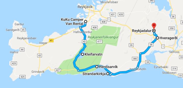 DIA –> KEF on a slightly delayed flight thanks to lightning in Denver. 6.5 hours and one aurora experience later, we arrived in Iceland!! After a chaotic airport experience (too many tourists landing at once, too small of an airport), we took a ride to Kukucampers to pick up “Carl vanElf,” our camper van/home for the next 18 nights. After a grocery shopping trip to Bónus , we began our road trip exploring a bit of the Reykjanes Peninsula, stopping at Kleifarvatn, Krysuvík, Grænavatn, Herdísarvík, Strandakirkja, and Kjöt og Kúnst geothermal restaurant in Hveragerði before hiking up to geothermal river in Reykjadalur valley for a deserved soak. We stayed the night at the campground in Hveragerði.
Day 2 – Read all about it in full detail with photos HERE!

First full day! Woke up to crazy rain which gave away to good weather for our modified Golden Circle day. Started out with the Kerið crater after harassing some Icelandic horses by the roadside, and then stopped by the Ljósafossstöð hydropower station on the way to Þingvellir National Park. In Þingvellir we saw the first glimpse of the tourist hoards (yay tour buses…), along with Öxarárfoss waterfall (foss = waterfall in Icelandic), Drekkingarhylur (“Drowning Pools”…where they use to drown women for variety of offenses), Lögberg, Þingvallakirkja (kirkja = church), and walked in between the North American and Eurasian tectonic plates. After a lunch on the shores of Þingvallavatn (Iceland’s largest lake), we headed towards Brúarfoss waterfall. This required quite the muddy walk, and then detour around private property. This was the first place we filled a water bottle from a river, which is a no-no in the US… so exciting to drink from one of my favorite waterfalls! Post waterfall hike we enjoyed freshly made ice cream at Efstidalur II, where windows looked out into the cowshed, so a cow could stare me down as I ate my banana ice cream. Then it was onward to the Secret Lagoon, or Gamla Laugin, for a nice long hot springs soak. We ended the day in Hella, where we’d stay for two nights. We cooked some Icelandic hot dogs for dinner and made a bunch of breakfast burritos for our highland adventure the next day.
Day 3 – Read about it in full detail with photos HERE!

Landmannalaugar! The land of my dreams! We took a Trex 4×4 bus into the highlands, where we’d have roughly 8 hours to hike and explore. The drive in and out was a treat on the F-roads (interior mountain roads for 4WD/AWD only, which is why we couldn’t drive Carl there), as we had stunning views of a snowy Hekla (another volcano) and moon-like volcanic landscapes. Once arriving in Landmannalaugar, we set out to climb Mount Brennisteinsalda (855 meters), which is an actual volcano (I learned that just now). Landmannalaugar is like being on a completely different planet… the scenery simply does not seem real whatsoever! Hands down one of the most beautiful places I have ever been. After the summit we descended through the Laugahraun lava fields. We finished off with a long soak in the natural hot pool, and then boarded the bus for our two hour drive back to the campground in Hella.
Day 4 – Read about it in full detail with photos HERE!
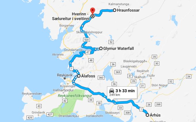 On this day we began our official circle of the entire island clockwise after spending a few days in the southeast and highlands. We departed Hella, stopping at a suburb of Reykjavík named Mosfellsbær so I could go shopping for an Icelandic wool sweater at Álafoss, and stopped for some groceries, the post office, and an ATM to get some local currency. We also filled up Carl for the first time, which was a stressful experience for me as Icelandic gas pumps are very different than what we have in the states, but in the end we got it all figured out. We opted to drive around Hvalfjörður, stopping at some waterfalls we found along the way. After lunch, we did the hike to what was Iceland’s highest waterfall (but still the highest accessible one), Glymur. The hike was pretty amazing, with rain, steep scrambles with ropes/chains, cave you must walk through, and a river crossing. Though Glymur was in the mist, it was still a very beautiful sight! We then continued on to Hraunafossar and Barnafoss, both unique waterfalls. On the way to the campsite for the night we stopped in Reykholt, home of Iceland’s most famous author Snorri Sturluson. We visited Snorralaug, a hot pot you are not allowed to swim in, and explored the church grounds. We stayed at the Hverinn campground in Kleppjárnsreykir, which was very quiet and lovely! We cooked a great dinner, and chatted up the owner who wishes to visit Aspen, CO one day. After a spectacular sunset, and my first European washing machine adventure, the aurora paid us a visit! In my excitement to get photos, I forgot to focus the camera, so I got many awesome blurry photos. Still absolutely amazing to see the aurora in real life. ‘Twas a good day.
Day 5 – Read about it in full detail with photos HERE!
 This was a jammed packed day as we drove through the gorgeous Snæfellsnes peninsula, also known as “Little Iceland” since it offers a bit of the whole country in a compact package. Sights/stops included:
Landbrotalaug – small hot pot, with a line waiting to use it so we had to skip it
Fáskrúðarbakki church
Ölkelduvatn mineral springs
Staðastaður church
Bjarnarfoss
Búðakirkja – probably one of the most famous churches in Iceland, just the little black church by the sea
Rauðfeldsgjá – gorge with stream/waterfall that took a bit of rock climbing skills to crawl into. Had cannibalistic birds inside it, but was super awesome otherwise
Arnarstapi – we walked along the shore after a lunch in the sunshine by the Bárðar Saga Snæfellsáss Statue. By this time we were in tee shirts and shorts and sandals! Who says Iceland doesn’t get warm?! Also saw the Gatklettur arch.
Hellnar – stopped to look at the church and find the Kcymaerxthaere. “Interdimensional Hopscotch” marker
Londrangar – rock formations in the ocean and lighthouse
Djúpalónssandur – black sand beach (more like big pebbles). Walked through lava formations called Nautastígur and then past a shipwreck. There are 4 stones on the beach called lifting stones of various weights. I cracked open my elbow playing around trying to lift one… whoops! It was great to sit in the sun and watch the waves and ocean
Saxhóll Crater – 398 stairs to the top of this old volcanic crater, which provided panoramic views of the mountains, ocean, and distant Westfjords
Saxhólsbjarg / Svörtuloft – bird cliffs and lighthouse that look a very bumpy “road” to get to
Skarðsvik Beach – Amazing white sand beach where we watched the sunset and cooked up some broccoli cheese soup
After a very busy, full day of adventures, sun, and fun, we pulled into the Hellissandur campground after dark. Our van doors opened up to a view of Snæfellsjökull, the glacier capped volcano that had my attention all day (and was the passage to Earth’s center in “Journey to the Center of Earth”).
Day 6 – Read all about it in full detail with photos HERE!

An early morning start from Hellissandur as we had stuff to see and a ferry to the Westfjords to catch! First stop was the waterfall above Ólafsvík, which I could never quite find a name for, but it was a unique cone shape and best yet, no one else was there! Then we journeyed on to Kirkjufellsfoss, where we had breakfast, and then took some classic Iceland tourist photos at one of the most photographed places in the country. Leaving crowds behind, we drove to Sheep’s Waterfall, which is a little less crowded, and has the perk of being able to get behind the falls in a cave, which smelled like sheep. Next up was a short and sweet hike up Helgafell, or “Holy Mountain.” Legend has it that you circle Guðrún Ósvífrsdóttir’s grave 3 times counterclockwise (I messed up and went clockwise), and then climb the mountain without talking, turning around, and with a pure heart. At the top you make three wishes facing east. At the base of Helgafell is a small gift shop and friendliest sheep dog ever! Next up was a resupply for gas and groceries at Bónus in Stykkishólmur, which is “Nuuk, Greenland” in the “Secret Life of Walter Mitty.” After some sandwiches for lunch, we located some buildings from the movie. Soon enough it was time to board the Ferry Baldur to Brjánslækur in the Westfjords across Breidafjörður Bay. This was my first ever car ferry experience, and at the very least, I survived (I don’t like boats). We saw a whale, seal, and jellyfish during our 2+ hour journey. The ferry also had a short stop at Flatey, a lonely, but inhabited island in the bay. Once on the other side we set up camp in Flókalundar, and walked a short bit of trail to a natural hot springs called Hellulaug. All along the trail were wild bilberries, which are similar to blueberries, so we stuffed our faces as we walked. Hellulaug overlooked the ocean, and was a wonderful way to end our exciting day!
Day 7 – Read all about it in full detail with photos HERE!

Into the Westfjords we go! A short drive from our campground we visited another natural hot pot overlooking the fjord, Krossholtslaug, which we had all to ourselves. After a nice long soak it was time to drive some “infamous” Westfjords gravel roads that wind up and over mountain passes and through the fjords. The roads are narrow, have no guard rails, and are often on the side of cliffs or the ocean. Definitely a place for people who love driving! We had a quick stop at the top of the first pass at Kleifabúi, an interesting stone statute. As we descended down to Patreksfjörður, we saw a seal sunning themselves. Then it was on to the Garðar BA 64 shipwreck, a boat that beached in 1981. The stunning scenery continued as we worked our way to Látrabjarg, which are famous bird cliffs and also the westernmost point of Iceland (and Europe if you don’t count the Azores, which nobody does). Talk about feeling like you’re at the end of the world! We enjoyed a few miles of walking along the cliffs in brilliant sunshine, and then cooked some lunch. Then it was back on the same roads, with a stop at the Minjasafn Egils Ólafssonar Hnjótur Museum. It was filled with maritime items, and an exhibit on a famous sea rescue that occur at Látrabjarg. Along detour along the way was down Road 614, which has quite the reputation for being “scary,” to Rauðisandur, a red sand beach. Then it was up and over more mountains and along more fjords to Bíldudalur, our stop for the night. We walked around the town a little bit, which was heavily void of any tourists (very nice). Our campsite was next to a big inflatable bounce pad, which are very common at schools and parks in Iceland (lawsuit liability in America, clearly), and looked out into Arnarfjörður. We had our first experience with horse meat, which was a grocery store mistake. It tasted a lot like wild game meet. All the while we got harassed by some very bored local children. This is the Iceland I came to experience… wild roads, locals, fjord views, and getting away from it all… and a bounce pad!
Day 8 – Read all about it in full detail with photos HERE!

We set out from Bíldudalur to Reykjafjarðarlaug, a swimming pool and natural hot pot at the end of Arnarfjörður, seemingly in the middle of nowhere. Then it was more classic Westfjords roads as we drove towards Dynjandi, the crown jewel of the Westfjords. Dynjandi is made up of 7 waterfalls: Dynjandi, Hæstahjallafoss, Strompgljúfrafoss, Göngumannafoss, Hrísvaðsfoss-Kvíslarfoss (opposite each other), Hundafoss and Bæjarfoss. After a lunch at Dynjandi, it was time to head towards Ísafjörður, the largest “city” in the Westfjords. We drove through a 9km tunnel, Göng undir Breiðadals og Botnsheiði, which was awesome because it had an intersection in the middle. The tunnels in Iceland are quite the marvel, and some are even one lane! Once reaching Ísafjörður we picked up some groceries and gas, and then set out to explore the town. I finally would meet some Icelandic cats (must pet all the cats!). We had 7pm reservations at Tjöruhúsið, one of the most renowned restaurants in Iceland. Tjöruhúsið is a fish/seafood restaurant that serves whatever they caught that day buffet style. Everyone sits at long picnic tables, which added to the atmosphere. The fish soup and bread was amazing, and for not being a fish eater, I enjoyed the various dishes from the main course as well. We reached our campsite, Tungudalur, on the outskirts of town, after dark. Tungudalur has it’s own waterfall, and some very nice facilities. I was in a food coma and didn’t do much except pass out!
Day 9 – Read all about it in full details with photos HERE!

We awoke to rain and fog in Ísafjörður. First stop was Gamla Bakaríið, a local bakery, for some sweets and coffee. Icelandic coffee is insanely good! Then it was onwards into the moody landscape. As we wrapped around Hestfjörður we came across cars stopped in the middle of the road, and saw that there was a pack of whales swimming in the fjord! We took some photos and then continued on to beat the traffic. We stopped quickly to see the seals at their normal spot on the beach of Skötufjörður, and then it was on to Litlibær, another one of my “must sees” of the trip. Litlibær is a historical farmhouse that now serves up homemade waffles, tea, and coffee, along with some homemade jams and sweaters. Best waffles ever! Bellies full, we continued in and out of the fjords, catching a good view of the Drangajökull glacier. We detoured to Reykjanes, an odd settlement with a heavy Soviet feel to it, and an interesting man in a towel smoking cigarettes. In Ísafjörður (the fjord, not the town we left in the morning) we found a hidden gem of a waterfall that we took a short walk to, and Kubo braved the icy waters for a short swim. By now the clouds had given away to sun and blue skies, because in Iceland the weather changes every 5 minutes. We traveled to Hólmavík, the location of the Museum of Sorcery and Witchcraft… aka the home of the Necropants. After learning some crazy stuff about Iceland’s history and witchcraft lore, we backtracked slightly to Drangsnes, our stop for the night. This small town is situated on Steingrímsfjörður, and has a set of 3 hot tubs that sit on the shore. We cooked a spaghetti dinner, and decided to do some laundry before heading down for a soak. Everything was ok until the wash cycle was done… and the washer door would not open. The handle ended up coming off in the groundskeeper’s hands! I, naturally, was stressing out, but Kubo saved the day with a set of butterknives to trigger the latch to open. After this ordeal, a nice long soak and beer was definitely in order in the hot tubs for our last night in the Westfjords!
Day 10 – Read all about it in full detail with photos HERE!

We left Drangsnes and the Westfjords behind, setting out for northern Iceland and rejoining the Ring Road. The long drive was getting to me, so we made a stop at Prestsbakki, a church where we got out and stretched out legs. This was a big day of driving, with over 6 hours to cover. The first main stop was Hvítserkur, which is a sea stack that looks like some sort of animal bent over drinking. I must admit, I was very underwhelmed by this stop. Not sure if it was due to leaving the magical Westfjords, or if it’s just simply overrated. Next was a lunch stop at Borgarvirki, a unique rock feature that had been used as defensive fortification during the settlement era. A little jaunt down the road we stopped at Kolugljúfur gorge, where we donned rain gear to get close to the waterfall. This is definitely a unique gem, though tour buses have discovered it as well. We rejoined the Ring Road, stopping in Blönduós for coffee and gas before continuing on. In Blönduós the light posts have knitted Icelandic sweater-like wrappings on them! Lots of time in Carl on this day. Next stop was a historical turf church called Víðimýrarkirkja, which kicked off an afternoon of turf structures. Next up was Glaumbær, which is an exhibit of historical turf houses and buildings, along with a church that is next door. We then turned north to head up Tröllaskagi, or Troll Peninsula. We stopped at one of the oldest churches in Iceland, Grafarkirkja, before arriving at our final destination, Hofsós. Before settling into camp we explored the tiny town a bit, stopping to admire the basalt columns on the shore line of Skagafjörður.
Day 11 – Read all about it in full detail with photos HERE!

Before heading out of Hofsós we visited the town swimming pool, which kind of looks like an infinity pool into the fjord. Nearly every town in Iceland has a public pool, which is great as you can soak, swim, and get a shower… or even eat ice cream for breakfast like we did! We then continued around the Tröllaskagi peninsula in the rain, going through a couple of tunnels which are always a blast. We stopped for lunch in Akureyri, which is Iceland’s second largest city with a whopping 17,000 people. We ate at Bakaríið við Brúna, which was very reasonably prices and had delicious pizza and goulash. Probably some of the best food of the trip! Akureyri also has heart shaped red lights! Next stop was Goðafoss, where we watched kayakers go off the falls and enjoyed walking around the area. We also got to witness a rather hilarious road rage fight in the parking lot with the word “imbecile” being said a lot. Tourists! Finally it was time to head towards Mývatn, a lake area with a lot of geothermic and volcanic activity. We first hiked a few miles at a lava field called Dimmuborgir, doing the Kirkjuhringur to a feature called the Church, and detouring to the Yule Lads Cave as well. Then we drove a bumpy road out of Hverfjall crater, which is like leaving earth and landing on the moon. Otherworldly, no other way to describe it. After a straight up hike to the top, the Mývatn area spread out below us in beautiful fashion. But seriously, we definitely were on the moon. No way it was earth! This is one night we chose to eat out, eating at Vogafjós Cowshed Cafe. After visiting the milk cows, we were seated. Kubo had the lamb fillets, which he enjoyed. I had a vastly undercooked hamburger. I was not too impressed with this restaurant, and definitely think we ate at a lot better (and cheaper) places during our trip. Afterwards, we had about one hour to soak in the Mývatn Nature Baths (Jarðböðin). This is like a mini Blue Lagoon, as it has the same blue silica water that is really just run off from a power plant… but is way less crowded and half the price. We stayed there until they closed, and then settled into our campground, Bjarg, around 11pm.
Day 12 – Read all about it in full detail with photos HERE!

We leave Mývatn and head to another extreme… the tippy top of the northeast. If barely any tourists go to the Westfjords, nobody goes to the northeast. But first, some more stops around Mývatn. First is driving through the geothermic power plant Krafla, to hike around a crater with a lake in the middle called Viti. It was muddy and super noisy from the steam vents. Actually all very interesting! On our way back to the road there is a shower in the middle of nowhere essentially. The water is a perfect temperature for bathing, and it runs constantly. Definitely one of my trip highlights! We then made a quick stop at Hverir, a geothermic area much like Thermopolis or Yellowstone. Then north we headed. We detoured to see Æðarfossar, a set of waterfalls that drain into the Arctic Ocean, and then stopped at an overlook near Lónsós. Ásbyrgi was our next stopped, a gorgeous forested area inside a horseshoe canyon, where the fall colors of leaves were on full display. Legend has it the canyon is really a hoof print from Odin’s horse. Going from volcanic wastelands to ocean coasts to a forested canyon is quite the trip, but that’s Iceland – an everchanging landscape around every corner. We hiked to the pond called Botnstjörn, and then up one of the cliffsides for a panoramic view after having some lunch. Driving north less and less people were seen. The highways in Iceland are not highly trafficked as it is, but as we drove up the Melrakkaslétta peninsula we definitely felt like we were the last two humans left on earth. We finally came across other humans (barely) in Raufarhöfn before journeying onto the 2nd northernmost point of mainland Iceland, Hraunhafnartangi. We hiked out to the point, which is only 3km from the Arctic Circle! After watching the waves for quite awhile, we returned to Raufarhöfn for the night. We would be the only people in the campground. Definitely another “we’re at the edge of the world” moments.
Day 13 – Read all about it in full detail with photos HERE!

Before leaving Raufarhöfn, we stopped at the Arctic Henge, which is a Stonehenge-esque project. Then it was time to hit the lonely roads in the rain heading south. The next major stop was Gljúfursárfoss, a waterfall that drains into Vopnafjörður. Then it was up Road 917, one of the highest mountain passes in Iceland, which goes up over Hellisheiði. We ascended into the clouds, popping out of them on the other side to an amazing panoramic view of the ocean, valley below, and all the switchbacks of the gravel road awaiting us. Definitely worth the drive! After some groceries and fuel in Egilsstaðir, we headed up Road 93 towards Seydisfjorður. First we hiked up to Fardagafoss, which was a beautiful climb and the bonus is we could go behind the falls, which had a cave. After the hike it was time for a drive I’ve been anticipating for years down 93 into Seydisfjörður. This road is part of the infamous long boarding scene in “The Secret Life of Walter Mitty,” which was the movie that made me want to visit Iceland. After a spirited drive down the pass, we explored the town, starting at Seyðisfjarðarkirkja and the rainbow painted sidewalk. We hiked up to Tvísöngur, or sound sculpture that is suppose to represent the 5 harmonies in traditional Icelandic singing. We then checked into the town’s campground and set out for Kaffi Lára El Grilló Bar for dinner and beers. Kubo got the leg of lamb which was delicious, and I braved another undercooked hamburger. Both of our meals came with the best baked potatoes we’ve ever eaten. We then walked back to the campground and settled in for a cold, rainy night.
Day 14 – Read all about it in full detail with photos HERE!

1*C weather and freshly fallen snow on the mountains greeted us in the morning in Seydisfjörður. First stop for the day was a hike up to Hengifoss, the 3rd highest waterfall in Iceland (2nd highest accessible). On the way up to Hengifoss we passed by another waterfall, Litlanesfoss, which has awesome basalt columns surrounding it. The river that forms both falls flows into Lagarfljot. After the hike we backtracked down the road, and stopped in the Hallormsstaður National Forest for some lunch, and to enjoy being in a very un-Icelandic landscape. We then rejoined the Ring Road and wove our way into and out of the east fjords, being treated to amazing scenery. Just when I thought Iceland couldn’t wow me any further… it did! We made a quick stop in Stöðurvarfjörður at Petra’s Stone Collection, but decided to not enter the exhibit. Next quick stop was at Sveinsstekksfoss, a waterfall hidden up a dirt road in Berufjörður. In and out of the fjords we went were greeted with clearing skies and amazing views. In Djúpivogur we stopped at Eggin í Gleðik. This art display on the harbor consists of 34 huge granite eggs which represent the eggs of each of the nesting birds in this area, many of which are migrating birds, flying over to Iceland from far away to lay their eggs in Iceland created by Sigurður Guðmundsson. We continued on as the views got crazier and crazier, so we stopped for photos quite often, including at Lækjavik, and finally stopping for the night at Stafafell Nature Park. This was a basic campground where sheep and the Northern Lights came included, along with a view of the backside of the Vesturhorn mountains.
Day 15 – Read all about it in full detail with photos HERE!

So begins the jam-packed south coast journey. We got an early morning start from our campsite at Stafafell, first stopping at a wooden red chair that is bolted down to a random rock on the side of the Ring Road. Then it was onto the black sand beach of Stokksnes and Vestrahorn mountains. We ate a buffet breakfast and had coffee at the Viking Cafe before playing around in the black dunes and getting some photos. We then went for a soak in the Hoffell hot pots, which kinda sit near the base of Hoffellsjökull glacier. Next up was Jökulsárlón, one of Iceland’s most famous sights. Sitting at the base of Breiðamerkurjökull glacier, this is a lagoon that is formed by the melting glacier, and icebergs break off and float off into the ocean. Pieces of icebergs wash up on what is known as Diamond Beach. Since Jökulsárlón is a madhouse, we drove over to a smaller glacier lagoon, Fjallsárlón, for lunch. This glacier lagoon is formed by a melting Fjallsjökull, and has crowds, but they’re smaller. After a crazy bumpy drive, we arrived at Svínfellsjökull glacier, and hiked a bit alongside it until the trail cliffed out too much for our comfort. We then settled into the awesome Svínafell campground, which had nice views, a waterfall, sheep, and great amenities.
Day 16 – Read all about it in full detail with photos HERE!

We headed to Vatnajökulsþjóðgarður, or Vatnajökull National Park, and more specifically, Skaftafell. We first hiked to Svartifoss, a unique waterfall characterized by black basalt columns. Then we hiked to Sjónarnípa, which is a viewpoint over Skaftafellsjökull glacier. Then it was time to drive across the sandurs, which are pretty much volcanic wastelands that span from the glaciers/mountains on the north to the ocean on the south. Finally the landscape gave way to the typical lava-moss fields and green mountains as we approached Kirkjubæjarklaustur. Here we drove quickly by Stjórnarfoss. Then it was onto Fjaðrárgljúfur, a 2 million year old canyon carved by the Fjaðrá river. Next up was one trip highlight for me… playing in the moss covered Eldraun lava fields! This lava field was created during one of the largest recorded volcanic eruptions since the Ice Age, and is covered in neon green moss that creates a stunning, surreal landscape… which I could’ve stayed in forever. Daylight was beginning to fade, so a quick stop was made a Laufskálavarða, a place covered in cairns. Travellers crossing the Mýrdalssandur for the first time would pile stones up to make a cairn, which was supposed to bring them good fortune on the journey. I added a rock, and jumped back in the warm van. Finally we arrived in Vík, the southernmost village in Iceland, and also the rainiest. Yep, it started dumping rain! After some quick photos at the church and a trip to the grocery store, we settled into the muddy campground for the night.
Day 17 – Read all about it in full detail with photos HERE!
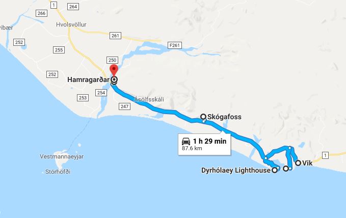
After raining cats and dogs overnight in Vík, we awoke to clear skis! We set out for Reynisfjara, or as most people know it, “the super famous black sand beach.” Reynisfjara beach is known for Reynisdrangar, basalt sea stacks. Next up was going over to Dyrhólaey peninsula, which has a lighthouse, and panoramic views of Reynisfjara, Mýrdalsjökull, and the southern coastline all the way east to Selfoss. Then then worked our way over to Skógafoss, one of the most popular sights for tourists. But instead of looking at the waterfall we headed up the steep stairs that begin the 26km long Fimmvörðuháls hiking trail. We would hike a little more than 5 miles up the trail from Skógar, passing countless waterfalls, and getting grand views of Eyjafjallajökull volcano (of 2010 grounded air travel fame). We turned around once we reached the lava fields and the bridge over the Skóga river. The final stop was at Seljalandsfoss, which we caught at sunset. This waterfall you can walk behind and makes for great photos. We also walked over to Gljúfrabúi, waterfall concealed in a small canyon. We camped at Hamragarðar which borders the falls, and was the most awful campground of the whole trip unfortunately. The aurora came out ever so faintly, however.
Day 18 – Read all about it in full detail with photos HERE!
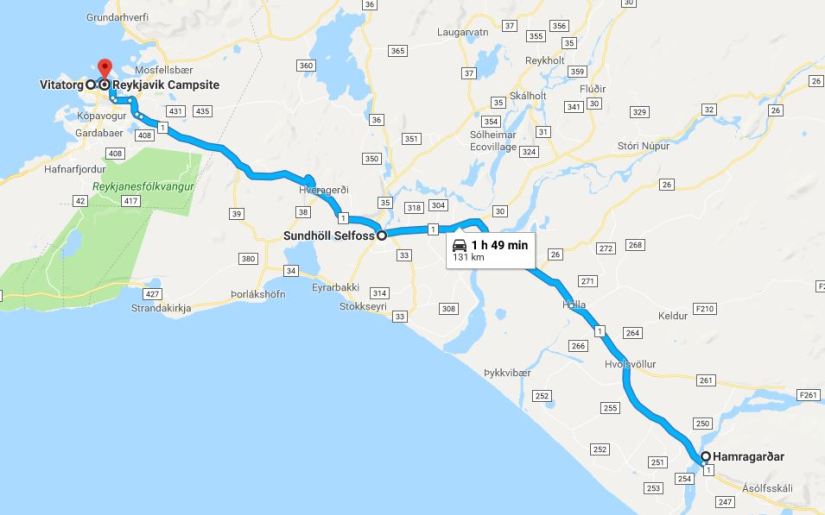
We would leave the nature behind and begin our journey to Reykjavík. First we stopped at the town pool in Selfoss for a soak, swim, and shower. After soaking and freshening up, it was onwards to the big city of 122,000 people. After locating parking, we took off walking, with my first goal being Kattakaffihúsið, or the cat cafe! We enjoyed coffees and snacks while I petted all the cats and got cat hair all over myself. We then went to Litla Jólabúðin, the Christmas store, and bought souvenirs and gifts. We walked down Laugavegur, the main downtown shopping district, and made our way to the Icelandic Phallological Museum… or penis museum. 280 mammalian specimens awaited us. It was actually a quite interesting museum to say the least, if not educational! Hungry, we ate at The Noodle Station across the street, getting probably our cheapest meal out. After big bowls of pho we headed to Hallgrímskirkja, one of the tallest buildings in Iceland and largest church. We then headed to the Harpa concert hall and walked around the harbor a bit as we headed to the Sun Voyager sculpture. Perfect timing, it started raining as we got to the sculpture, which was nicely across the street from the parking garage. We settled into the Reykjavík city campground for the night, which has very nice facilities, including a large kitchen space, free food shelves, and plenty of bathroom facilities. And just like that… the last night in Iceland sleeping in Carl the Van was here
Day 19 – Read all about it in full detail with photos HERE!

What a sad day. Not much happened this day… we woke up, dragged our butts at breakfast, and begrudgingly drove towards Keflavík and the airport. Leaving Carl was super sad! The airport experience was a lot smoother than arriving, aside from my bag almost getting sent to Boston. They make you walk through duty free stores twice which is clever on their part.
Some notes –
- This is a driving intensive itinerary. My boyfriend and I are very use to long days in the car being from Colorado and Wyoming, so we are not bothered by long road trips as it’s normal to drive 5-8 hours to get somewhere where we live. Our longest day was Day 10, which about 6+ hours of driving. We are also very experienced with narrow and/or gravel roads, so we weren’t slowed down by those.
- We did not do any guided tours, aside from taking the 4×4 bus into Landmannalaugar. Guided tours are just not our thing. They might be yours, and that’s ok 🙂
- We were lucky to still have long daylight hours in September. This itinerary would not have been doable in the later fall/early spring (and obviously winter) months. In summer time we could’ve done even more!
- Yes, the Blue Lagoon is missing. We have no desire to visit there. The many natural hot pots we got to experience, along with developed pools, are far better in our opinion.
- Geysir and Gullfoss are missing, too?! Yes, indeed. We were running short on our time during Day 2 for our Golden Circle, so I omitted these so we could enjoy a leisurely hike to Brúarfoss and long soak at Secret Lagoon, and still make it to our campsite in Hella with some daylight left. We decided pretty quick that this would not be our last trip to Iceland, so we were okay with leaving these out. And for me, having visited Yellowstone, I wasn’t “needing” to see another geyser. Next trip!
- But what about stopping for all the pretty sights? We were lucky in the fact that Kubo did all the driving (he loves driving) and I sat in the passenger seat with my Nikon D500 and 18-200mm lens and took literally thousands of photographs while moving down the road. A lot of places you cannot safely pull off the road, so this really helped to capture everything in a safe manner. Kubo still stopped a lot when stuff caught his eye, or when I spotted a church I just had to stop and see up close.
- I did have Jeannie Riley with Iceland with a View review this itinerary about one month before departure. To toot my own horn, she was very impressed by what I created, confirmed it was doable (especially with our background of long road trips), and answered the handful of questions I had. Worth the money to ease my anxiety on if I had planned too much into each day.
- We set an alarm for about 0600 every morning, give or take. Some days we were up and at it at 0700, other days it was closer to 0900 before we were rolling out of the campground. There were only two nights we reached our campground for the night after dark. Some days we hit the road before eating breakfast so we could see a sight or two, or at least enjoy breakfast with a more scenic view than the campground.

This sounds incredible, I would love to go to Iceland
LikeLike
It’s an amazing, mind blowing place! Around every corner is something new and fantastic!
LikeLike
well done, bravo! and I like your choices (what you skipped, in order to do what you did…)
LikeLike
Thank you!!
LikeLiked by 1 person
Awesome blog! We lived in Laramie for many years so it’s great to get the perspective of a fellow Wyomingite who also favors gravel roads and solitude. We are headed to Iceland in 10 days for a 17 day trip and plan to take a similar tour of the Ring Road and Westfjords. Your blog has been very helpful, thanks for sharing.
LikeLike
Hello Jim! I am from Laramie! I hope you have a wonderful trip, I am sure you are going to enjoy it and notice the similarities between Wyoming and Iceland! Thank you for stopping by and reading my blog!
LikeLike